m (Changing Australische to Australia) |
m (→Nations) |
||
| (12 intermediate revisions by 3 users not shown) | |||
| Line 1: | Line 1: | ||
| − | Australia is the smallest inhabited continent, both in terms of size and by population. The main landmass is Australia itself. The interior is mostly scrubland and desert. The north and north-east coasts are ringed by |
+ | Australia is the smallest inhabited continent, both in terms of size and by population. The main landmass is Australia itself. The interior is mostly scrubland and desert. The north and north-east coasts are ringed by rain forest. The next main island groups are the Maori Islands, mountainous, volcanic but with a mild climate. Spanning almost all of the [[Roasjoinn (The Kalmar Union)|Roasjoinn]] between Australia and [[Leifia (The Kalmar Union)|Leifia]]/[[Tawantinland (The Kalmar Union)|Tawantinland]] are countless smaller island chains and coral reefs, some barely above sea-level. |
==Historical Overview== |
==Historical Overview== |
||
| − | The continent of Australia ''or Terra Australis Incognito'' was known to Chinese and Javan traders for centuries before its discovery in 1854 by Luxembourgoise explorers operating out of [[Luxembourg (The Kalmar Union)#Singapore|Singapore]]. |
+ | The continent of Australia ''or Terra Australis Incognito'' was known to [[China (The Kalmar Union)|Chinese]] and Javan traders for centuries before its discovery in 1854 by Luxembourgoise explorers operating out of [[Luxembourg (The Kalmar Union)#Singapore|Singapore]]. |
A full survey would wait for another three years when a Kalmar ship, the 'Nymark' circumnavigated the coast. Both Kalmar and Luxembourg claimed the land for their own and began to build coastal forts to back up the claims. The rapid militarisation of the continent threatened to lead to the outbreak of general war and also to the break up the Kalmar Union itself as its members squabbled about their individual claims. |
A full survey would wait for another three years when a Kalmar ship, the 'Nymark' circumnavigated the coast. Both Kalmar and Luxembourg claimed the land for their own and began to build coastal forts to back up the claims. The rapid militarisation of the continent threatened to lead to the outbreak of general war and also to the break up the Kalmar Union itself as its members squabbled about their individual claims. |
||
| Line 9: | Line 9: | ||
The Australia Treaty of 1868 designated borders between the claims of [[Luxembourg (The Kalmar Union)|Luxembourg]], [[Denmark (The Kalmar Union)|Denmark]], [[Gothenland (The Kalmar Union)|Gothenland]], [[Svealand (The Kalmar Union)|Svealand]]. Both [[Aragon (The Kalmar Union)|Aragon]] and [[Byzantine Empire (The Kalmar Union)|Byzantine Empire]] were also confirmed with land as they had taken the opportunity given by the stand-off to capture and garrison their own regions. Also agreed was a portion of land to be governed by the native population. |
The Australia Treaty of 1868 designated borders between the claims of [[Luxembourg (The Kalmar Union)|Luxembourg]], [[Denmark (The Kalmar Union)|Denmark]], [[Gothenland (The Kalmar Union)|Gothenland]], [[Svealand (The Kalmar Union)|Svealand]]. Both [[Aragon (The Kalmar Union)|Aragon]] and [[Byzantine Empire (The Kalmar Union)|Byzantine Empire]] were also confirmed with land as they had taken the opportunity given by the stand-off to capture and garrison their own regions. Also agreed was a portion of land to be governed by the native population. |
||
| − | The various Roasjoinn islands to the East of Australia are either sovereign nations in their own right or under control of various powers; either one of the main European powers, the Chinese or the Tawantinsuyu. |
+ | The various Roasjoinn islands to the East of Australia are either sovereign nations in their own right or under control of various powers; either one of the main European powers, the Chinese or the [[Tawantinsuyu (The Kalmar Union)|Tawantinsuyu]]. |
==Nations== |
==Nations== |
||
| + | <center> |
||
{|class="wikitable sortable" style="text-align:center;" width=70% |
{|class="wikitable sortable" style="text-align:center;" width=70% |
||
| − | |+ |
+ | |+Australian Nations |
| ⚫ | |||
!No. on Map |
!No. on Map |
||
! Country |
! Country |
||
| Line 28: | Line 30: | ||
|- |
|- |
||
|2 |
|2 |
||
| − | |[[ |
+ | |[[New Brabant (The Kalmar Union)|New Brabant]] <small>[[Luxembourg (The Kalmar Union)|(United Netherlands)]]</small> |
|Sophiastad |
|Sophiastad |
||
|[[File:Flag of New Brabant (Kalmar Union).svg.png|23px|border]] |
|[[File:Flag of New Brabant (Kalmar Union).svg.png|23px|border]] |
||
| Line 37: | Line 39: | ||
|Wulagi |
|Wulagi |
||
|[[File:Flag of Alawaland (Kalmar Union).svg.png|23px|border]] |
|[[File:Flag of Alawaland (Kalmar Union).svg.png|23px|border]] |
||
| + | |Director Oodgeroo Yirrkala |
||
| ⚫ | |||
|- |
|- |
||
|4 |
|4 |
||
| Line 52: | Line 54: | ||
|- |
|- |
||
|6 |
|6 |
||
| − | |[[ |
+ | |[[Danish Australia (The Kalmar Union)|Danish Australia]] <small>[[Denmark (The Kalmar Union)|(Denmark)]]</small> |
|Australskobing |
|Australskobing |
||
|[[File:Flag of Danish Australische (Kalmar Union).svg.png|23px|border]] |
|[[File:Flag of Danish Australische (Kalmar Union).svg.png|23px|border]] |
||
| Line 67: | Line 69: | ||
|Arawa |
|Arawa |
||
|[[File:Flag of Kieta (The Kalmar Union).svg.png|23px|border]] |
|[[File:Flag of Kieta (The Kalmar Union).svg.png|23px|border]] |
||
| + | |King Kabui II |
||
| − | | |
||
|- |
|- |
||
|9 |
|9 |
||
| Line 82: | Line 84: | ||
|- |
|- |
||
|11 |
|11 |
||
| − | |[[ |
+ | |[[New Zeeland (The Kalmar Union)|New Zeeland]] <small>[[Luxembourg (The Kalmar Union)|(United Netherlands)]]</small> |
|Elizabethstad |
|Elizabethstad |
||
|[[File:Flag of New Zeeland (The Kalmar Union).svg.png|23px|border]] |
|[[File:Flag of New Zeeland (The Kalmar Union).svg.png|23px|border]] |
||
| Line 88: | Line 90: | ||
|- |
|- |
||
|12 |
|12 |
||
| − | |[[Loaisa Islands (The Kalmar Union)|Loaisa Islands <small>(France)</small> |
+ | |[[Loaisa Islands (The Kalmar Union)|Loaisa Islands]] <small>[[France (The Kalmar Union)|(France)]]</small> |
|Louisville |
|Louisville |
||
|[[File:Flag of Loaisa Islands (The Kalmar Union).svg.png|23px|border]] |
|[[File:Flag of Loaisa Islands (The Kalmar Union).svg.png|23px|border]] |
||
| Line 97: | Line 99: | ||
|Yaren |
|Yaren |
||
|[[File:Flag of South Azores (The Kalmar Union).svg.png|23px|border]] |
|[[File:Flag of South Azores (The Kalmar Union).svg.png|23px|border]] |
||
| + | |King Manuel IV |
||
| − | | |
||
|- |
|- |
||
|14 |
|14 |
||
| Line 112: | Line 114: | ||
|- |
|- |
||
|16 |
|16 |
||
| − | |[[ |
+ | |[[Viti (The Kalmar Union)|Viti]] |
|Suva |
|Suva |
||
| − | |[[File:Flag of |
+ | |[[File:Flag of Viti (The Kalmar Union).png|23px|border]] |
|King Seru |
|King Seru |
||
|- |
|- |
||
| Line 124: | Line 126: | ||
|- |
|- |
||
|18 |
|18 |
||
| − | |[[ |
+ | |[[Danish Polynesia (The Kalmar Union)|Danish Polynesia]] <small>[[Denmark (The Kalmar Union)|(Denmark)]]</small> |
|Papeete |
|Papeete |
||
|[[File:Flag of Danish Polynesia (The Kalmar Union).svg.png|23px|border]] |
|[[File:Flag of Danish Polynesia (The Kalmar Union).svg.png|23px|border]] |
||
| Line 135: | Line 137: | ||
|Duke Stephan III |
|Duke Stephan III |
||
|} |
|} |
||
| − | |||
[[File:Australische.png|thumb|650px|The Nations of Australia]] |
[[File:Australische.png|thumb|650px|The Nations of Australia]] |
||
| + | </center> |
||
| + | {{AustraliaKU}} |
||
{{KU}} |
{{KU}} |
||
[[Category:The Kalmar Union]] |
[[Category:The Kalmar Union]] |
||
[[Category:Nations (The Kalmar Union)]] |
[[Category:Nations (The Kalmar Union)]] |
||
[[Category:Australian and Oceanian countries]] |
[[Category:Australian and Oceanian countries]] |
||
| + | [[Category:Australia]] |
||
Revision as of 12:42, 10 May 2019
Australia is the smallest inhabited continent, both in terms of size and by population. The main landmass is Australia itself. The interior is mostly scrubland and desert. The north and north-east coasts are ringed by rain forest. The next main island groups are the Maori Islands, mountainous, volcanic but with a mild climate. Spanning almost all of the Roasjoinn between Australia and Leifia/Tawantinland are countless smaller island chains and coral reefs, some barely above sea-level.
Historical Overview
The continent of Australia or Terra Australis Incognito was known to Chinese and Javan traders for centuries before its discovery in 1854 by Luxembourgoise explorers operating out of Singapore.
A full survey would wait for another three years when a Kalmar ship, the 'Nymark' circumnavigated the coast. Both Kalmar and Luxembourg claimed the land for their own and began to build coastal forts to back up the claims. The rapid militarisation of the continent threatened to lead to the outbreak of general war and also to the break up the Kalmar Union itself as its members squabbled about their individual claims.
The Australia Treaty of 1868 designated borders between the claims of Luxembourg, Denmark, Gothenland, Svealand. Both Aragon and Byzantine Empire were also confirmed with land as they had taken the opportunity given by the stand-off to capture and garrison their own regions. Also agreed was a portion of land to be governed by the native population.
The various Roasjoinn islands to the East of Australia are either sovereign nations in their own right or under control of various powers; either one of the main European powers, the Chinese or the Tawantinsuyu.
Nations
| No. on Map | Country | Capital | Flag | Current Head of State |
|---|---|---|---|---|
| 1 | Queen Isabellas Land (Aragon) | New Cervera | King Peter VIII | |
| 2 | New Brabant (United Netherlands) | Sophiastad | Queen Charlotta | |
| 3 | Alawaland | Wulagi | Director Oodgeroo Yirrkala | |
| 4 | Svealandic Australia (Svealand) | Rebekkastadt | King Gustav IX | |
| 5 | New Oland (Gothenland) | Koskull | King John VII | |
| 6 | Danish Australia (Denmark) | Australskobing | King Christopher X | |
| 7 | South Euboea (Byzantium) | Alexanderoplis | Emperor Ivan XIV | |
| 8 | Kieta | Arawa | King Kabui II | |
| 9 | Drehu Federation | Noumea | ||
| 10 | United Maori States | Takapuna | Moka Kerehona | |
| 11 | New Zeeland (United Netherlands) | Elizabethstad | Queen Charlotta | |
| 12 | Loaisa Islands (France) | Louisville | King Charles XIII | |
| 13 | South Azores (Portugal) | Yaren | King Manuel IV | |
| 14 | Svealandic Polynesia (Svealand) | Funafuti | King Gustav IX | |
| 15 | Samoa | Apia | Prince Lauaki | |
| 16 | Viti | Suva | King Seru | |
| 17 | Tonga | Nuku'alofa | King Ha'ateiho II | |
| 18 | Danish Polynesia (Denmark) | Papeete | King Christopher X | |
| 19 | Frysian Polynesia (Fryslân) | Tubuai | Duke Stephan III |
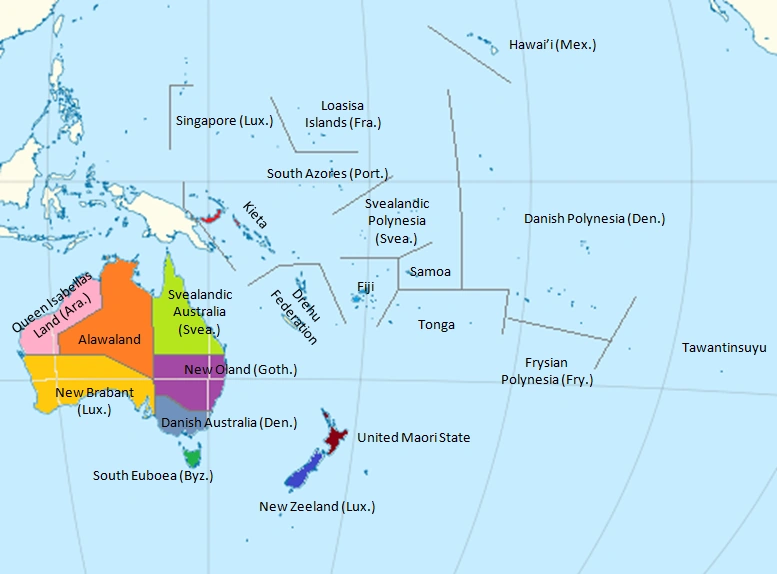
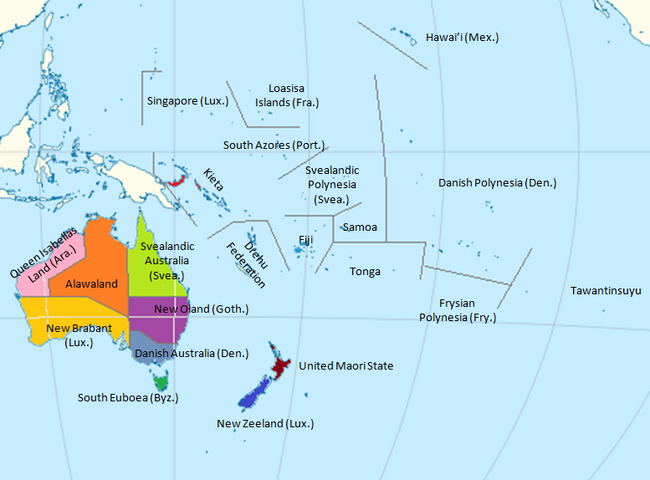
The Nations of Australia
| |||||||||||
| ||||||||||||||||||||