| |||||||
| Capital | Tegucigalpa | ||||||
| Largest city | Guatemala City | ||||||
| Language | Spanish | ||||||
| Demonym | Central American | ||||||
| President | Antonio Saca | ||||||
| Prime Minister | Porfirio Lobo Sosa | ||||||
| Established | 27 May 1833 | ||||||
| Currency | Central Pesos | ||||||


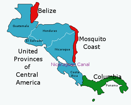
The United Provinces of Central America, usually referred to as simply Central America, is a constitutional federal republic located in North America, that borders Columbia to its south and the United Mexican States, usually referred to as Mexico, to its north.
History[]
The area, despite regional discontent, remained a part of Mexico following the War of South American Independence, where the Mexican government, like the Emperor, managed to maintain control on a tide of nationalism. However, starting in 1829, discontent finally flared up dramatically, primarily against the monarchy. In Central America, the Captaincy General and its sub-areas declared their neutrality in the small civil war in the rest of Mexico. The quick victory of the republicans did little to change this, though they continued to formally remain part of Mexico. The rebellions launched against the new Mexican government all over meant that anything else could not be enforced in the area. The coup launched on the 17th of May, 1833 by General Santa Anna was meant with a quick official declaration of independence by the region ten days later, on the 27th.
Politics and Government[]
Provinces[]
Economy[]
The Nicaraguan Canal runs through the Southern areas of the United Provinces, from the Caribbean to the Pacific. It runs from the Caribbean along the much widened and deepened San Juan River to Lake Nicaragua, where a system of canals and locks takes it across the remainder of the distance to the Pacific. Revenues from the Canal form a significant part of the budget of the nation.