No edit summary |
(found a heightmap: Groningen City is built on the northernmost hill of the Hondsrug apparently, most of the city proper would in fact remain dry.) |
||
| Line 8: | Line 8: | ||
Although located mostly below sea level {{1983DD|Friesland}} escaped most of the flooding. In Friesland lack of manpower was not immediately an issue but fuel was quickly running out. A solution was found by once again using the old school method of keeping dry feet by using windmills as water pumps. Most old windmills, whether intended as pumps or not, were put to this use and many new ones were constructed. Though the lands are vastly wetter using these methods and only the higher lying ground can be used to raise crops, the lower lying lands are still much suited to keeping livestock. |
Although located mostly below sea level {{1983DD|Friesland}} escaped most of the flooding. In Friesland lack of manpower was not immediately an issue but fuel was quickly running out. A solution was found by once again using the old school method of keeping dry feet by using windmills as water pumps. Most old windmills, whether intended as pumps or not, were put to this use and many new ones were constructed. Though the lands are vastly wetter using these methods and only the higher lying ground can be used to raise crops, the lower lying lands are still much suited to keeping livestock. |
||
| − | In [[North Germany (1983: Doomsday)#German Expansion|Groningen]] similar methods were used, but with much less success. Given the anarchic conditions that gripped the province at the time these efforts were much less coordinated, and thus less effective. This allowed the city of |
+ | In [[North Germany (1983: Doomsday)#German Expansion|Groningen]] similar methods were used, but with much less success. Given the anarchic conditions that gripped the province at the time these efforts were much less coordinated, and thus less effective. This allowed the city of for great parts of the Groninger countryside to sink into swampland. The city of Groningen, though its northernmost quarters too have sunk into the swamp, came to be situated on a peninsula, only having a true land connection to the south into Drenthe. Because of this, life in the city deteriorated, and the city is largely abandoned. |
Today the Dutch Wastelands are seen as a useless navigational hazard for travelers. Because of the widespread tidal flooding the Frisian island chain now extends up to the former border of Belgium. The Dutch wastelands are today claimed by the {{1983DD|Netherlands Antilles}}, though no actual functioning government exists here. |
Today the Dutch Wastelands are seen as a useless navigational hazard for travelers. Because of the widespread tidal flooding the Frisian island chain now extends up to the former border of Belgium. The Dutch wastelands are today claimed by the {{1983DD|Netherlands Antilles}}, though no actual functioning government exists here. |
||
Revision as of 15:24, 17 June 2010
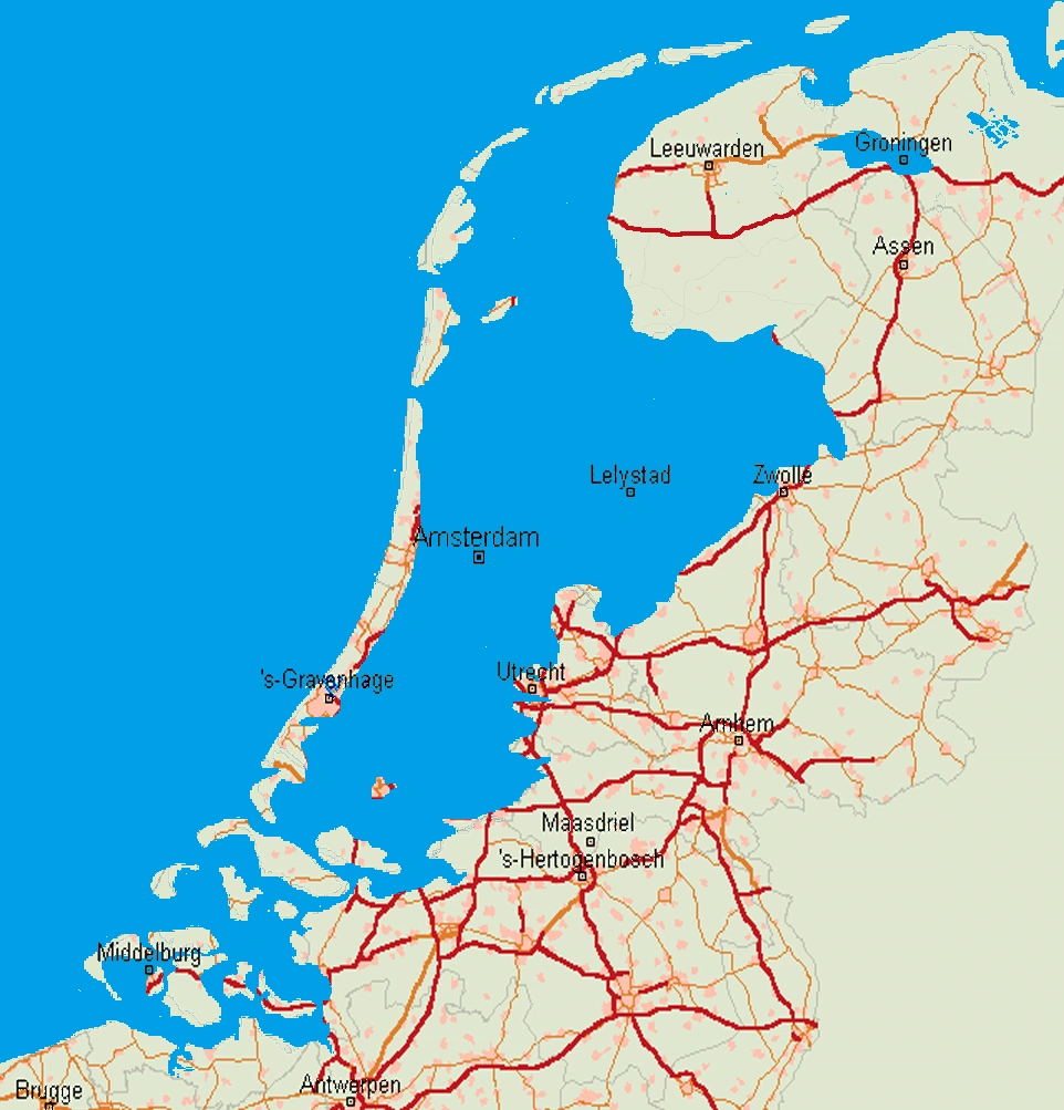
A map of the Dutch Wastelands among the former cities of the Netherlands
The Dutch Wastelands (sometimes called the Holland Wastelands) is a geographical area created after Doomsday. It is a large swamp covered area located in the former Netherlands. Prior to Doomsday the Netherlands was a geographically low-lying country, with about 27% of its area and 60% of its population located below sea level. These areas were gained through land reclamation and preserved through an elaborate system of polders and dikes.
On September 26, 1983 the Netherlands and its neighboring countries were hit by several nuclear missiles. These completely destroyed several urban areas and killed millions. As a side affect several of the dikes and polders set up in these areas were destroyed as well, causing minor flooding in these areas. More serious and lasting however was the lack of manpower set up for maintaining Holland's drainage system. The drainage pumps, lacking fuel, skills and people to operate them, remained inoperative after Doomsday. Slowly these areas began sinking back into sea from which they came.
Over the next few years almost half of the country began to fill up with brackish water, subsequently transforming the areas into radiation infested swamps prone to being flooded by the sea. Meanwhile plant life began to reclaim the area and cover the swamped cities and towns. Soon the only signs of past civilization left were crumbling ruins of former settlements halfway filled with water. There remain very few people who still live in these cities. Although a few nomads and reclusive inhabitants can be sporadically found living in the area, they number in the mere thousands in a region which once held over 10 million people.
Although located mostly below sea level Friesland escaped most of the flooding. In Friesland lack of manpower was not immediately an issue but fuel was quickly running out. A solution was found by once again using the old school method of keeping dry feet by using windmills as water pumps. Most old windmills, whether intended as pumps or not, were put to this use and many new ones were constructed. Though the lands are vastly wetter using these methods and only the higher lying ground can be used to raise crops, the lower lying lands are still much suited to keeping livestock.
In Groningen similar methods were used, but with much less success. Given the anarchic conditions that gripped the province at the time these efforts were much less coordinated, and thus less effective. This allowed the city of for great parts of the Groninger countryside to sink into swampland. The city of Groningen, though its northernmost quarters too have sunk into the swamp, came to be situated on a peninsula, only having a true land connection to the south into Drenthe. Because of this, life in the city deteriorated, and the city is largely abandoned.
Today the Dutch Wastelands are seen as a useless navigational hazard for travelers. Because of the widespread tidal flooding the Frisian island chain now extends up to the former border of Belgium. The Dutch wastelands are today claimed by the Netherlands Antilles, though no actual functioning government exists here.
The fate of the Dutch Wastelands remains uncertain. Although radiation levels have dropped they remain too high for safe rehabilitation at present, especially with continued radiation from the Rhine and Meuse rivers. Although there have been talks of eventual resettlement by the Netherlands Antilles, these remain minor and unofficial. It is most likely, barring major rehabilitation, the Dutch Wastelands will sink completely beneath the North Sea over the next few decades, becoming a shallow, irradiated bay of the North Sea.