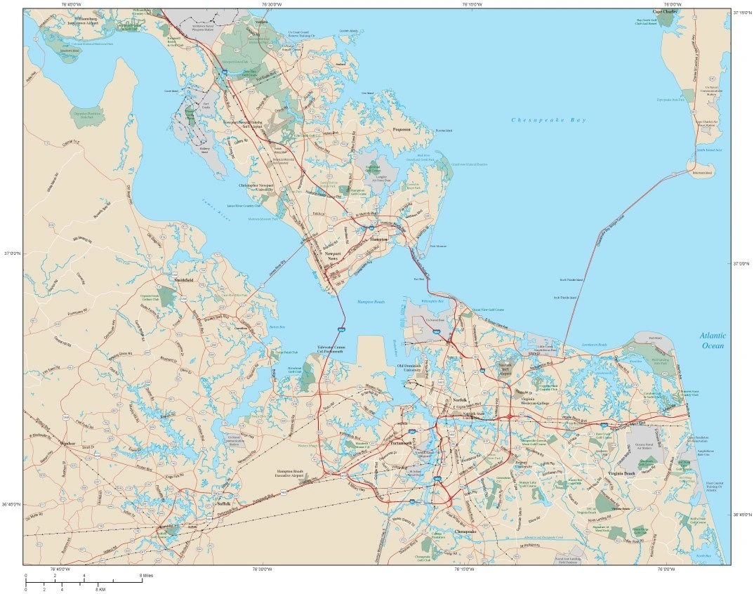
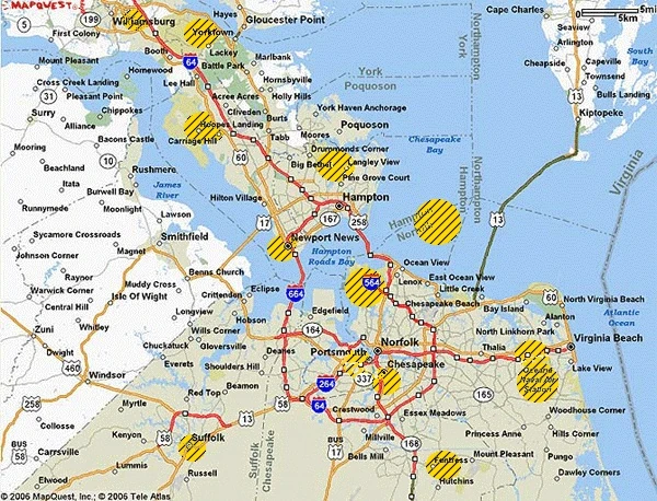
Hampton Roads was a vast metropolitan region located in the southeastern area of the former US state of Virginia. It consisted of the cities of Norfolk, Newport News, Hampton, Virginia Beach, Portsmouth, Suffolk, Chesapeake, Poquoson, and Williamsburg, with an estimated population of over 1.1 million people as of the 1980 Census. The area was destroyed in 1983 during Doomsday, because of the significant concentration of strategic US military facilities.
Background[]
Hampton Roads Region as it looked in 1983
Hampton Roads was one of the world's largest natural, ice-free harbors, incorporating the mouths of the James and Elizabeth Rivers which flowed into Chesapeake Bay near its entrance to the Atlantic Ocean. The communities which made up the area, encompassed the lower part of the Virginia Peninsula, which included Williamsburg and Yorktown, extending to South Hampton Roads, which included Norfolk, Newport News, Hampton, and Virginia Beach, which bordered by the Atlantic Ocean to the east.
The third largest port in the US at the time, much of the regional economy was based on the processing of imports and exports, shipbuilding and repair, and cargo transfer and storage. It was home to the Norfolk News Shipbuilding and Dry dock Company, the largest privately owned shipyard in the nation. Hampton was also a leader in the US for the exporting of coal and an important transportation hub for the railroad. Virginia Beach was an important destination for tourists.
US Military Presence[]
Hampton Roads was also a significant part of US military operations, primarily the US Navy, serving as home to the largest concentration of military bases in the world. These facilities included:
- Norfolk Naval Station, Norfolk: The largest naval station in the world at the time, the base supported 75 ships and approximately 134 planes. Spread across 3400 acres, NS Norfolk repaired and refit US Naval ships and trained their crews. The station had 14 piers and 11 aircraft hangers. Headquarters for the US Fleet Forces Command, is was also the home of the US Navy Second Fleet.
- Langley Air Force Base, Hampton: The home of the First Tactical Fighter Wing, which included the 71st Fighter-Interceptor Squadron and 27th Fighter Squadron, which contained the first F-15 Fighter Wing. The 6th Airborne Command and Control Squadron (EC-135s) also stationed there.
- Camp Peary, Williamsburg; 9275 acre military reservation which housed Armed Forces Experimental Training Activity (AFETA) under the auspices of the Department of Defense. Also home to "The Farm," a covert training facility of the CIA.
- Fort Eustis, Newport News: Home of the US Army Transportation Corps, responsible for the movement of personnel and material by truck, rail, air, and sea.
- Fort Story, Virginia Beach: US Army Logistics Over the Shore (LOTS) training and test site.
- Fleet Training Center Dam Neck, Virginia Beach: US Navy Fleet Combat Training Center
- Norfolk Naval Shipyard, Portsmouth: The largest industrial facility belonging to the US Navy, it handled the rebuilding, remodeling, and repairing of US Navy ships.
- Naval Air Station Oceana, Virginia Beach: The only master jet base on the US East Coast, the facility was home to the US Navy fighter jet fleet, with a primary mission of training and deploying naval fighter squadrons for the US Atlantic Fleet.
- Naval Amphibious Base Little Creek, Virginia Beach: The major operating center by the US Navy Atlantic Fleet for training of amphibious forces.
- Naval Weapons Station Yorktown: Spread out over 20 acres, the main weapons and ammunition storage and loading facility for ships of the US Atlantic Fleet.
Doomsday[]
Because of the catastrophic destruction which occurred on Doomsday and the resulting lack of witnesses, historians and government officials have experienced great difficulty over the years in piecing together the actual sequence of events which took place in Hampton Roads on the evening of September 25, 1983 when the Soviets attacked. Based on extensive research, most of it by Delmarva, an approximate picture now exists.
The first report of the impending Soviet attacks were believed to have been received by the various military facilities between 8:45 PM and 8:50 PM. With the military status at DEFCON 1, commands were issued to immediately scramble and evacuate all air, submarine, and surface ship assets stationed in the vicinity. Given it was Sunday night, many of those who normally might have been present were unavailable. Crews of many ships were on shore leave and as such scattered about. Nonetheless, a concerted effort was made to put as many planes in the air as possible and get what ships and submarines there were out of the harbor and to sea, even if they had less than their regular complements.
News of the impending attack was received by civilian authorities at about 8:55 PM with the announcements out of Washington, DC. Television and radio stations immediately began broadcasting evacuation warnings through the emergency broadcast system. Sirens also began to go off over the various regions. Local residents as well as some of the military stationed in the area attempted to evacuate, with those in the Virginia Peninsula heading west and those in South Hampton heading north along the Chesapeake Bay Bridge to the Delmarva Peninsula or south towards North Carolina.
Roads quickly became gridlocked with motor vehicles, preventing many from escaping. It was later estimated at least 1500 to 2000 may have escaped over the Bay Bridge, partially because it was late Sunday and traffic was light and signs were quickly adjusted to allow only for one way traffic. At about 9:15 PM, the EMP generated by the Soviet detonation of a nuclear weapon in the atmosphere over the central US, disabled nearly all electricity and communications throughout the region. Many vehicles also stopped functioning as their ignitions burned out, helping to contribute to gridlock. In many cases, vehicles were abandoned as people attempted to flee on foot.
Military units attempting to evacuate were also damaged or incapacitated. Although US military vessels and planes were somewhat hardened to deal with EMPs, they nevertheless were not impervious. Many ships drifted about as crews struggled to gain control and some helicopters and planes crashed starting fires, while others struggled to try and safely land somewhere.
Chronology of Attack[]
Known Soviet nuclear strikes in Hampton Roads, Virginia on September 25, 1983
The attack came in three waves:
First Wave The first wave arrived at about 9:20 PM EDT, when two one megaton devices detonated over Hampton Roads with-in minutes of each other. The first went off directly over the US Naval Station in Norfolk, completely obliterating it. As the shock wave swept outward it destroyed the two key bridges of the Hampton Roads Beltway, one linking Norfolk to Hampton and the other Norfolk to Newport News. The Craney Island Industrial area southwest of the explosion, which served as the major fueling depot for the US Navy, was wrecked by both the shock wave and a small tidal wave generated by the explosion causing numerous explosions and fires. Tidal waves also swept inland along Newport News and Hampton causing damage.
The second warhead exploded over the Norfolk Naval Shipyard on the Elizabeth River eight miles south of the Naval Station, destroying it and a large portion of the surrounding area of Portsmouth. The northern part of the shock wave struck Norfolk, already heavily damaged by the first strike, and the southern part Chesapeake. Another result of the explosion was to significantly block up or dam the Elizabeth River.
Second Wave The second wave, which arrived 15 minutes later, involved strikes by 500 kiloton warheads throughout Hampton Roads.
Oceana NAS was hit by one warhead which exploded at ground level destroying the facility. A second warhead believed to have been targeted for the facility exploded prematurely over the Kings Grant neighborhood of Virginia Beach. The two explosions caused massive damage to Virginia Beach.
A warhead exploded south over the Fentress District of Chesapeake, apparently intended for the Fentress Air Naval Landing Field which was an auxiliary field for Oceana NAS.
Two warheads targeted Langley Air Force Base destroying the site along with a portion of the city of Hampton. It also heavily damaged part of Newport News and the nearby Fort Monroe.
A single warhead destroyed the Norfolk News Shipbuilding and Dry dock Company shipyards on the James River in Newport News. The blast heavily damaged Newport, already hard hit by the shock waves from the strikes on Langley AFB. The explosion also destroyed the James River Bridge connecting Newport News with Isle of Wight County.
Another warhead exploded over the central portion of the Naval Weapons Station Yorktown near the York River. The blast and shock wave severed the Colonial Parkway and heavily damaged the Naval Supply Center Cheatham Annex to the north. To the south the shock wave heavily damaged Interstate 64 and to the west caused moderate damage to Williamsburg.
Fort Eustis was struck by one warhead which directly exploded above the central portion of the base destroying most the command and control areas and heavily damaging the remaining areas including the Felker Army Airfield. The shock wave also struck part of the heavily damaged Naval Weapons Station Yorktown to the north. Collateral damage included Interstate 64 and Newport News-Williamsburg International Airport.
A final warhead believed to have headed for Camp Peary, overshot the target and detonated near Lightfoot destroying the town. The dead included a number of tourists staying in nearby motels and hotels. The blast wave damaged Williamsburg, including William and Mary College to the south, and part of Camp Perry to the west.
Third Wave The third and final wave, which consisted of at least three warheads in the one megaton range, came down at approximately 9:45 PM to 9:50 PM. Analysts generally believe this final wave was designed to destroy anything which still remained. It is unclear at to exactly where these warheads were destined and there are some indications the weapons may have been off target. It is known one exploded over Suffolk on the Nansemond River, with a second landing in or near the city of Chesapeake, which had already been severely damaged.
The third warhead however detonated directly over Chesapeake Bay, roughly between Buckroe Beach in Hampton to the west, and the Chesapeake Bay Bridge to the east. It is believed this detonation was targeted at any ships which may have been at anchorage or might still have been underway at the time. The explosion created a series of large tidal waves which swept out in all directions. Waves at least 200 feet high slammed into the ruins of Hampton Roads. To the west of the detonation, waves engulfed Hampton and Newport News, sweeping in at least as far as the devastated ruins of Langley AFB. Other waves pushed down the mouth of Hampton Roads and into the James and Nansemond Rivers. South of the explosion, waves swept inland across Norfolk, pushing in 15 to 20 miles, possibly to the ruins of Portsmouth. To the southeast, water destroyed a large portion of the Chesapeake Bay Bridge which was still standing and swept inland several miles, including sweeping over Fort Story and the Naval Amphibious Base Little Creek. Farther out, waves caused less significant damage northeast along the tip and parts of the lower western shore of the Delmarva Peninsula and northwest around Mobjack Bay and adjacent areas.
Weather Conditions[]
Prior to the attack on September 25, 1983, weather patterns had varied throughout Hampton Roads. Although temperatures had averaged about 70 degrees, winds varied from six to 15 miles-an-hour around Hampton and Norfolk to calm around Virginia Beach. When the attack commenced, temperatures had dropped to about 60 degrees and winds remained light from six to three miles-an-hour blowing east from Norfolk, 2.3 miles an hour blowing southeast to west from Hampton, to 2.3 miles traveling east from Virginia Beach.
Fallout[]
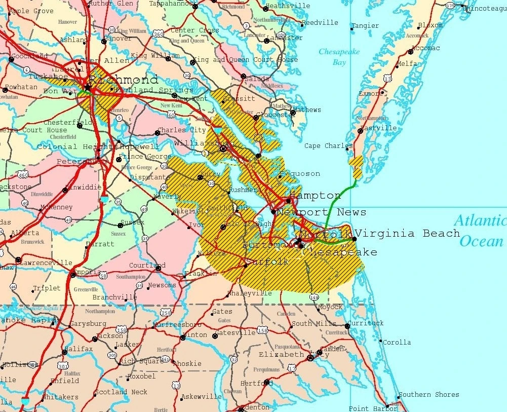
Areas of southeastern Virginia contaminated by radioactive and toxic fallout due to Doomsday
The attacks generated hundreds of small and large fires throughout the region, feeding on such sources as burning fuel, munitions, and chemicals. Within a short time many of these fires had merged into larger firestorms, which reportedly generated lightning and tornadoes. Cinders and ash were deposited over a wide area igniting more blazes no one was able to successfully battle due to the incapacitation of water systems and fire engines. These winds helped to spread massive clouds of not only radioactive fallout, but toxic smoke and fumes. By dawn of the next morning an area stretching from James County to the tip of the Virginia Peninsula and from Norfolk east to Virginia Beach and south almost to the North Carolina border was engulfed by a thick black miasma of fumes, smoke and fallout.
Post Doomsday[]
Information as to what exactly happened in Hampton Roads following Doomsday, is limited and questionable. Witnesses reported the region was cloaked in a black miasmatic fog for at least three days, only dissipating after tropical storm Dean, which formed on September 26, 1983, came ashore three days later. The estimated 60 plus mph winds and three to four inches of rain helped break up the cloud and extinguish many fires. Because of the extreme radioactive and toxicity levels, most of the region was abandoned and avoided for some time, in particular by its nearest neighbor, Delmarva.
Information developed since the war, indicate small groups of people did survive in parts of Hampton Roads. Many made their way south towards North Carolina or west towards the interior of Virginia. Exact numbers are unknown. Between 3,000 to 5,000 are believed to have made their way to Delmarva before and after the attacks. Most survivors who left afterwards made their way by boat. However, a few small parties headed north and eventually found passage over the Chesapeake Bay, including survivors from Camp Perry, including CIA employees and agents. The actual number of how many survived from Hampton Roads is unknown. One study produced by the Delmarva Department of Heath indicated at least one-half of post strike survivors who made it to their nation, died within weeks and months because of their exposure.
Expeditions[]
Starting in 1984, Delmarva began sending small scouting parties to the area to see what conditions existed and if anything could be salvaged. They avoided hot spots, especially Norfolk, Hampton, Portsmouth, and Virginia Beach. They mostly observed long range by boat and or seaplane an apocalyptic landscape of craters, scorched land, and the skeletal remains of buildings which had burned or collapsed. They saw no evidence of life. Based on reports from these parties expeditions were organized to retrieve or rescue items of importance. Most of this work took place in and around the Virginia Peninsula.
Expeditions were able to recover stockpiles of fuel from several locations as well as salvaging valuable equipment from the Western Refining Facility near Yorktown. Supplies, including weapons, vehicles, and munitions were taken from the ruins of Fort Eustis, the Naval Weapons Station Yorktown, and Camp Perry. Expeditions exploring the US Army Transportation Museum at Fort Eustis, met success in recovering valuable models, documents, machinery, and vehicles. One team in particular was able to salvage several old US Navy ships which had been part of a mothballed fleet on the James River and carefully sail them back to Delmarva for renovation and use in the naval fleet. Historical artifacts have been removed from the ruins of such abandoned locations at Williamsburg, Jamestown, Yorktown, and William & Mary College. It is known that the Virginian Republic has conducted limited investigations in the last few years as well, however they have declined to reveal what they have done or may have recovered.
Present Day Conditions[]
Hampton Roads[]


Hampton Roads Region as it approximately appears as of 2011
Prior to Doomsday, much of the Hampton Roads landmass was already low lying and exposed to the sea. Scientists now believe the various detonations and intense fires of the war seriously damaged the stability of the land along with damming up and or redirecting the flows of various tributaries. These factors, combined with an increase in winter and summer storms and heavy rains have dramatically altered the region causing much of it to wash away or recede into the Chesapeake Bay and Atlantic Ocean. As of present day, the sea covers large areas of Hampton Roads, a phenomena which has been witnessed in may locations which were adjacent to the water and hit by multiple strikes. Delmarva has stated it has no intention of laying claim to any of the former land areas which still exist, preferring to leave it abandoned to nature.
Hampton Roads Roadstead and Harbor[]
The harbor-roadstead which made Hampton Roads a prime anchorage still exists, albeit cluttered by various underwater obstacles such as sunken ships and collapsed bridges in some locations. Beginning shortly after the war, Delmarva began to extend its territorial authority over the area. Delmarvan naval ships began to regularly patrol the region, which was being utilized to anchor freighters that had taken refuge in the nation following the war.
With the appearance of foreign commercial shipping and naval vessels in the 1990s, Delmarva permanently secured its hold over the roadstead and developed it into a popular and safe haven for vessels traveling along the North American East Coast or delivering supplies into the interior of North America. Regularly ships take refuge in the roadstead under the umbrella of the Delmarvan military to restock and relax in exchange for anchorage fees and trade relationships. The Delmarvan economy has seen a economic boom in the selling of fresh produce and meats to ships. Additionally, Delmarva allows the harbor to be used by Atlantic Defense Community naval ships who work jointly with the Delmarvan Navy on limited operations.
With the emergence of Virginian Republic shipping coming from their port of Hopewell on the James River, Delmarva reached an agreement with them to allow free passage of their commercial ships through the roadstead.
| ||||||||||||||||||||||