| |||||
| Country | Álengiamark | ||||
| Province | Margirhaedeyja | ||||
| Language | Álengsk | ||||
| Founded | c. 1130 | ||||
| Mayor | Bjárni Renap | ||||
| Population | 983,650 | ||||


Kristjanaborg is the capital of Margirhaedeyja Fylke. It is largest city in Álengiamark and second largest city in Leifia (outside of Mexica) after Fjallasay in Vinland. It has a estimated population of 983,650 and is predicted to grow larger than Fjallasay by 2030.
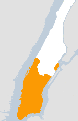
Marhaedeyja, with Kristjanaborg in Orange
It sits on the southern half of the island of Margirhaedeyja. To the East across the Austorass is the island and Fylke of Langaeyjar. To the west is the Kanienurass - the estuary of the Kanien River and end point of the Erie Canal. The thin Strait of Sjávurfjallun divides the island from the rest of Margirhaedeyja Fylke. Kristjanaborg Harbour to the south is one of the largest natural harbours in the world.
History
A settlement called 'Olafsbae' was first documented on the southern tip of Margirhaedeyja island in the Landtakabók of 1136. The Earls of Margirhaedeyja built their homestead there and for many decades it represented the Westernmost outpost of Álengsk territory. Some time around 1180 the original farm was split, Olafsbae in the West and Kristjanabae in the East. Coalescing around the earl's homestead Kristjanabae became Kristjanaborg and absorbed the old Olafsbae. After the vassalistion of the country by the Anyunwiyan Empire in 1239 the lands subject to the earls grew to incorporate a large area of Unamiland which enriched the city and encouraged its first growth spurt. By 1350 the southern tip of the island was encompassed by a set of walls and incorporated 24 stave churches, the earl's grand manor house as well as extensive dock buildings and warehouses. The port was busy with trade from the interior and along the coast, and was soon welcoming the first direct ships from Portugal.
The city was besieged in 1568 by the Leifian Protestant League but as they could not blockade it by sea the city did not fall. Soon after, the walls were constraining growth and a second set further to the north were built in 1603, almost doubling the area available. By 1650 almost 300,000 people were crammed into the city. Lawlessness, plague and the mob dominated the city for a century and the corrupt politics of the competing earl and mayoral palaces epitomised the inertia of 18th century Álengiamark. A series of painfully won royal reforms and army imposed law led to the creation of Margirhaedeyja Fylke. This stripped the earl of much of his land, allowing new towns and farmland to be built out in the hinterland. Kristjanaborg emptied as its citizens escaped its ever-worsening conditions and moved westwards to take advantage of the newly freed-up land. Two great fires in the 1780s seemed to finish off 'old Kristjanaborg'. Many of its old cramped and squalid buildings were torn down and the city opened up with new parkland, widened streets and imposing stone buildings such as the new Fylkdómsthét.
The Great Baltic War led a flood of Svealandic and Finnish settlers to Leifia, many of whose first sight of Leifia was Kristjanaborg. Whilst many stayed in the city others travelled to the freshly opening fylke of Nanticokeland. It would be the canny merchants of Kristjanaborg who setup the Chesapeake Company to fund and then profit from the immigrant farmers. With the vast profits of this venture they built spectacular homes in the growing city and sparked an expansion in the city's economy. They also, in a move that was much criticised at the time, bought up the farmland in the north of the island, preventing the slow northward expansion of the city's slums. Used as private parkland, the 'Nuthathenar' would eventually be sold to the crown which opened it for public use. Pressure from the city to be allowed to build on it has been repeatedly dismissed by the Althing in St. Hafdiss, instead preserving a valuable green space that is much used by the city's inhabitants.
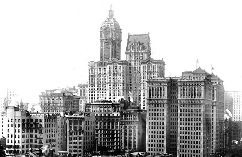

The skyline of Lower Kristjanaborg
The completion of the Erie Canal in 1911 led to another growth spurt as food and goods could be brought much more easily from the Fraeburt Votnum and the West. Steam trains soon penetrated the city on elevated rails binding the city to the mainland, and soon the long held dream of a bridge connecting Margirhaedeyja and Langaeyjar was realised. The Múkaustobrénn was the longest suspension bridge in the world on its completion in 1969, carrying trains and pedestrians over to the neighbouring towns of Grann and Ruttkrók. The city was electrified in 1984 and trams soon crisscrossed the city helping ease the traffic and loosening the dependence on horse drawn vehicles. Stronger building materials and the invention of the elevator have allowed tall buildings to be constructed and the city authorities appear to be in a competition with Copenhagen to build ever taller 'skyscrapers'.
In October 2012 the city and the surrounding towns were severely hit by Hurricane/Superstorm Svana. Some 2000 people are believed to have died and the still under construction Langaeyjar bridge was heavily damaged by the storm. While the city will no doubt suffer economically for a few years the general feeling is that it will bounce back stronger than ever.
| ||||||||||||||||||||||

| ||||||||||||||||||||
.png)
.png)