No edit summary |
(→States) |
||
| (42 intermediate revisions by the same user not shown) | |||
| Line 1: | Line 1: | ||
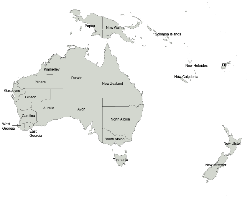
| − | [[File:Cygnia states map labelled.png|thumb|400px|A map of Cygnia showing its |
+ | [[File:Cygnia states map labelled.png|thumb|400px|A map of Cygnia showing its 21 states]] |
| − | The {{JoW|Cygnia|United Cygnian States}} is a {{w|federation}} consisting of |
+ | The {{JoW|Cygnia|United Cygnian States}} is a {{w|federation}} consisting of 21 [[#States|States]], a Federal Territory ({{JoW|Territory of Swan|Swan}}, which comprises the federal capital, {{JoW|Northam, TS|Northam}}), and five [[#External Territories|External Territories]]. The 13 contiguous states and the Territory of Swan are located on the mainland of {{w|Australia}}. The state of {{JoW|Tasmania}} lies to the south of {{JoW|Victoria}} across the Bass Strait. {{JoW|Aotearoa}} is southeast of both the mainland and Tasmania, across the Tasman Sea. {{JoW|Papua}} and {{JoW|New Guinea}} occupy the island of {{w|New Guinea}} to the north of {{JoW|New Zealand}}, and the other four states are located on islands to the northeast of the mainland, including {{JoW|Fiji}}, {{JoW|New Caledonia}}, the {{JoW|New Hebrides}} and the {{JoW|Solomon Islands}}. Cygnia also possesses six external territories, which are small islands lying to the northwest and northeast of the mainland. |
All the States are partially self-governing, and are represented in the {{JoW|Cygnian Congress}}; the External Territories, on the other hand, are administered exclusively by the federal government. four of the external territories are inhabited; the others are uninhabited, apart from non-permanent scientists. |
All the States are partially self-governing, and are represented in the {{JoW|Cygnian Congress}}; the External Territories, on the other hand, are administered exclusively by the federal government. four of the external territories are inhabited; the others are uninhabited, apart from non-permanent scientists. |
||
| − | {{JoW| |
+ | {{JoW|New Albion}} is the most populous state, with 23,687,400 residents (as of 2016); {{JoW|New Caledonia}} is the least populous, with an estimated 268,767 residents. The {{JoW|Territory of Swan}}, with an estimated 403,468 residents as of 2016, has a higher population than two states. The largest state by area is {{JoW|New Zealand}}, encompassing 1,852,642 square kilometres (263,983 square miles), while the smallest is the {{JoW|New Hebrides}}, encompassing 12,189 square kilometres (4,706 square miles). The first state to ratify the {{JoW|Imperial Constitution of Cygnia|Imperial Constitution}} was {{JoW|Carolina}}, which it did on 2 January 1792. The newest state is {{JoW|New Caledonia}}, which was admitted into the Federation on 5 May 1999. |
| − | The most recent entity to come under the sovereignty of Cygnia in its current form is {{JoW| |
+ | The most recent entity to come under the sovereignty of Cygnia in its current form is the {{JoW|Heard Island and McDonald Islands}}, which formally became an External Territory in 1910. |
==States== |
==States== |
||
| − | The table below lists the |
+ | The table below lists the 21 states, with their current capital, largest city, the date they ratified the {{JoW|Imperial Constitution of Cygnia|Imperial Constitution}} or were admitted to the Federation, population and area data, and number of representatives in the {{JoW|Cygnian House of Representatives}} (Each state is entitled to at least one Representative. Current law limits the number of representatives to 300, which are then apportioned among states every ten years according to their relative population. Each state is also entitled to four {{JoW|Cygnian Senate|Senators}}.) |
| − | {| class="wikitable |
+ | {| class="wikitable plainrowheaders" style="text-align: center;" |
| − | |+ States |
+ | |+ States of the United Cygnian States |
!scope="col" colspan=2 rowspan=2 |State & postal abbrieviation |
!scope="col" colspan=2 rowspan=2 |State & postal abbrieviation |
||
!scope="col" colspan=2 | Cities |
!scope="col" colspan=2 | Cities |
||
| − | !scope="col" |
+ | !scope="col" colspan=2 |Statehood |
!scope="col" |Population |
!scope="col" |Population |
||
!scope="col" rowspan=2 |Area in km<sup>2</sup> (mi<sup>2</sup>) |
!scope="col" rowspan=2 |Area in km<sup>2</sup> (mi<sup>2</sup>) |
||
| Line 23: | Line 23: | ||
!scope="col" | {{w|Capital city|Capital}} |
!scope="col" | {{w|Capital city|Capital}} |
||
!scope="col" | Largest |
!scope="col" | Largest |
||
| + | ! # |
||
| + | ! Date |
||
! (2016 est) |
! (2016 est) |
||
| ⚫ | |||
| + | ! nowrap align=left| [[File:NZ flag design Silver Fern (Black, White & Blue) by Kyle Lockwood.svg|30px]] {{JoW|Aotearoa}} |
||
| ⚫ | |||
| ⚫ | |||
| ⚫ | |||
| + | | 9th |
||
| ⚫ | |||
| + | | 4,899,660 |
||
| + | | 268,021 (103,483) |
||
| ⚫ | |||
|- |
|- |
||
! nowrap align=left| {{JoW|Auralia}} |
! nowrap align=left| {{JoW|Auralia}} |
||
| AU |
| AU |
||
| − | | {{ |
+ | | {{w|Esperance}} |
| − | | {{ |
+ | | {{w|Kalgoorlie}} |
| + | | 14th |
||
| − | | data-sort-value=" |
+ | | data-sort-value="14" | 23 April 1905 |
| 6,829,000 |
| 6,829,000 |
||
| 770,488 (297,487) |
| 770,488 (297,487) |
||
| − | | |
+ | | 13 |
|- |
|- |
||
| − | ! nowrap align=left| {{JoW|Avon}} |
+ | ! nowrap align=left| [[File:Flag of Campbell.png|30px]] {{JoW|Avon}} |
| AV |
| AV |
||
| − | | colspan=2 | {{ |
+ | | colspan=2 | {{w|Adelaide|Charlotte}} |
| + | | 4th |
||
| data-sort-value="4" | 26 April 1792 |
| data-sort-value="4" | 26 April 1792 |
||
| 7,259,100 |
| 7,259,100 |
||
| 1,043,514 (402,903) |
| 1,043,514 (402,903) |
||
| − | | |
+ | | 12 |
|- |
|- |
||
| − | ! nowrap align=left| {{JoW|Carolina}} |
+ | ! nowrap align=left| [[File:Flag of Peel.png|30px]] {{JoW|Carolina}} |
| CA |
| CA |
||
| − | | colspan=2 | {{JoW| |
+ | | colspan=2 | {{JoW|Perth}} |
| + | | 1st |
||
| data-sort-value="1" | 2 January 1792 |
| data-sort-value="1" | 2 January 1792 |
||
| 21,427,000 |
| 21,427,000 |
||
| 161,510 (62,359) |
| 161,510 (62,359) |
||
| − | | |
+ | | 35 |
|- |
|- |
||
| − | ! nowrap align=left| {{JoW|Darwin}} |
+ | ! nowrap align=left| [[File:Flag of the Northern Territory.svg|30px]] {{JoW|Darwin}} |
| DA |
| DA |
||
| − | | colspan=2 | {{ |
+ | | colspan=2 | {{w|Darwin|Palmerston}} |
| + | | 13th |
||
| ⚫ | |||
| ⚫ | |||
| 4,952,308 |
| 4,952,308 |
||
| 1,420,970 (548,640) |
| 1,420,970 (548,640) |
||
| Line 60: | Line 76: | ||
! nowrap align=left| {{JoW|East Georgia}} |
! nowrap align=left| {{JoW|East Georgia}} |
||
| EG |
| EG |
||
| − | | colspan=2 | {{ |
+ | | colspan=2 | {{w|Albany, Western Australia|Albany}} |
| + | | 3rd |
||
| data-sort-value="3" | 6 February 1792 |
| data-sort-value="3" | 6 February 1792 |
||
| 5,380,299 |
| 5,380,299 |
||
| Line 68: | Line 85: | ||
! nowrap align=left| {{JoW|Fiji}} |
! nowrap align=left| {{JoW|Fiji}} |
||
| FJ |
| FJ |
||
| − | | colspan=2 | {{ |
+ | | colspan=2 | {{w|Suva}} |
| + | | 16th |
||
| − | | data-sort-value=" |
+ | | data-sort-value="16" | 25 February 1950 |
| 898,760 |
| 898,760 |
||
| 18,274 (7,056) |
| 18,274 (7,056) |
||
| Line 76: | Line 94: | ||
! nowrap align=left| {{JoW|Gascoyne}} |
! nowrap align=left| {{JoW|Gascoyne}} |
||
| GA |
| GA |
||
| − | | colspan=2 | {{ |
+ | | colspan=2 | {{w|Carnarvon, Western Australia|Carnarvon}} |
| + | | 12th |
||
| − | | data-sort-value=" |
+ | | data-sort-value="12" | 2 September 1890 |
| 18,420,000 |
| 18,420,000 |
||
| 138,000 (53,000) |
| 138,000 (53,000) |
||
| Line 84: | Line 103: | ||
! nowrap align=left| {{JoW|Gibson}} |
! nowrap align=left| {{JoW|Gibson}} |
||
| GI |
| GI |
||
| − | | colspan=2 | {{ |
+ | | colspan=2 | {{w|Geraldton}} |
| + | | 15th |
||
| ⚫ | |||
| ⚫ | |||
| 1,352,920 |
| 1,352,920 |
||
| 472,336 (427,336) |
| 472,336 (427,336) |
||
| Line 92: | Line 112: | ||
! nowrap align=left| {{JoW|Kimberley}} |
! nowrap align=left| {{JoW|Kimberley}} |
||
| KI |
| KI |
||
| − | | colspan=2 | {{ |
+ | | colspan=2 | {{w|Broome, Western Australia|Broome}} |
| + | | 8th |
||
| ⚫ | |||
| ⚫ | |||
| 5,683,590 |
| 5,683,590 |
||
| 423,517 (163,521) |
| 423,517 (163,521) |
||
| − | | |
+ | | 11 |
| ⚫ | |||
| ⚫ | |||
| ⚫ | |||
| ⚫ | |||
| + | | 7th |
||
| ⚫ | |||
| ⚫ | |||
| ⚫ | |||
| ⚫ | |||
|- |
|- |
||
| − | ! nowrap align=left| {{JoW|New Caledonia}} |
+ | ! nowrap align=left| [[File:Flag of New Caledonia.svg|30px]] {{JoW|New Caledonia}} |
| NC |
| NC |
||
| − | | colspan=2 | {{ |
+ | | colspan=2 | {{w|Noumea}} |
| + | | 21st |
||
| − | | data-sort-value="22" | 5 May 1999 |
||
| ⚫ | |||
| 268,767 |
| 268,767 |
||
| 18,576 (7,172) |
| 18,576 (7,172) |
||
| 2 |
| 2 |
||
|- |
|- |
||
| − | ! nowrap align=left| {{JoW|New Guinea}} |
+ | ! nowrap align=left| [[File:Flag of Papua New Guinea.svg|30px]] {{JoW|New Guinea}} |
| NG |
| NG |
||
| − | | colspan=2 | {{ |
+ | | colspan=2 | {{w|Port Moresby}} |
| + | | 18th |
||
| − | | data-sort-value=" |
+ | | data-sort-value="18" | 16 September 1975 |
| 8,084,999 |
| 8,084,999 |
||
| 462,840 (178,700) |
| 462,840 (178,700) |
||
| 15 |
| 15 |
||
|- |
|- |
||
| − | ! nowrap align=left| {{JoW|New Hebrides}} |
+ | ! nowrap align=left| [[File:Flag of Vanuatu.svg|30px]] {{JoW|New Hebrides}} |
| NH |
| NH |
||
| − | | colspan=2 | {{ |
+ | | colspan=2 | {{w|Port Vila}} |
| + | | 20th |
||
| − | | data-sort-value=" |
+ | | data-sort-value="20" | 30 July 1980 |
| 270,402 |
| 270,402 |
||
| 12,189 (4,706) |
| 12,189 (4,706) |
||
| 1 |
| 1 |
||
| ⚫ | |||
| − | ! nowrap align=left| {{JoW|New Munster}} |
||
| ⚫ | |||
| ⚫ | |||
| ⚫ | |||
| ⚫ | |||
| − | | 1,115,800 |
||
| − | | 150,437 (58,084) |
||
| ⚫ | |||
| ⚫ | |||
| − | ! nowrap align=left| {{JoW|New Ulster}} |
||
| − | | NU |
||
| ⚫ | |||
| ⚫ | |||
| − | | 3,677,200 |
||
| − | | 113,729 (43,911) |
||
| − | | 7 |
||
|- |
|- |
||
! nowrap align=left| {{JoW|New Zealand}} |
! nowrap align=left| {{JoW|New Zealand}} |
||
| NZ |
| NZ |
||
| − | | colspan=2 | {{ |
+ | | colspan=2 | {{w|Brisbane}} |
| + | | 5th |
||
| data-sort-value="5" | 23 May 1792 |
| data-sort-value="5" | 23 May 1792 |
||
| 9,352,190 |
| 9,352,190 |
||
| Line 147: | Line 164: | ||
| 29 |
| 29 |
||
|- |
|- |
||
| − | ! nowrap align=left| {{JoW| |
+ | ! nowrap align=left| [[File:Morning Star flag.svg|30px]] {{JoW|Papua}} |
| ⚫ | |||
| ⚫ | |||
| ⚫ | |||
| ⚫ | |||
| ⚫ | |||
| ⚫ | |||
| ⚫ | |||
| − | ! nowrap align=left| {{JoW|Papua}} |
||
| PA |
| PA |
||
| − | | colspan=2 | {{ |
+ | | colspan=2 | {{w|Jayapura|Numbay}} |
| + | | 17th |
||
| data-sort-value="17" | 15 August 1963 |
| data-sort-value="17" | 15 August 1963 |
||
| 5,399,000 |
| 5,399,000 |
||
| Line 165: | Line 175: | ||
! nowrap align=left| {{JoW|Pilbara}} |
! nowrap align=left| {{JoW|Pilbara}} |
||
| PI |
| PI |
||
| − | | colspan=2 | {{ |
+ | | colspan=2 | {{w|Port Hedland, Western Australia|Port Hedland}} |
| + | | 11th |
||
| − | | data-sort-value=" |
+ | | data-sort-value="11" | 16 January 1885 |
| 7,534,190 |
| 7,534,190 |
||
| 507,896 (193,826) |
| 507,896 (193,826) |
||
| 13 |
| 13 |
||
|- |
|- |
||
| − | ! nowrap align=left| {{JoW|Solomon Islands}} |
+ | ! nowrap align=left| [[File:Flag of the Solomon Islands.svg|30px]] {{JoW|Solomon Islands}} |
| SI |
| SI |
||
| − | | colspan=2 | {{ |
+ | | colspan=2 | {{w|Honiara}} |
| + | | 19th |
||
| − | | data-sort-value=" |
+ | | data-sort-value="19" | 7 July 1978 |
| 599,419 |
| 599,419 |
||
| 28,400 (11,000) |
| 28,400 (11,000) |
||
| 2 |
| 2 |
||
| ⚫ | |||
| ⚫ | |||
| ⚫ | |||
| ⚫ | |||
| ⚫ | |||
| ⚫ | |||
| ⚫ | |||
| ⚫ | |||
|- |
|- |
||
! nowrap align=left| {{JoW|Tasmania}} |
! nowrap align=left| {{JoW|Tasmania}} |
||
| TA |
| TA |
||
| − | | colspan=2 | {{ |
+ | | colspan=2 | {{w|Hobart}} |
| + | | 6th |
||
| − | | data-sort-value="6" | |
+ | | data-sort-value="6" | 1 June 1792 |
| 1,566,000 |
| 1,566,000 |
||
| 68,401 (26,410) |
| 68,401 (26,410) |
||
| 5 |
| 5 |
||
| ⚫ | |||
| + | ! nowrap align=left| [[File:Flag of Victoria (Australia).svg|30px]] {{JoW|Victoria}} |
||
| ⚫ | |||
| ⚫ | |||
| + | | 10th |
||
| ⚫ | |||
| ⚫ | |||
| ⚫ | |||
| ⚫ | |||
|- |
|- |
||
! nowrap align=left| {{JoW|West Georgia}} |
! nowrap align=left| {{JoW|West Georgia}} |
||
| WG |
| WG |
||
| − | | colspan=2 | {{ |
+ | | colspan=2 | {{w|Bunbury, Western Australia|Bunbury}} |
| + | | 2nd |
||
| data-sort-value="2" | 9 January 1792 |
| data-sort-value="2" | 9 January 1792 |
||
| 9,523,101 |
| 9,523,101 |
||
| Line 205: | Line 220: | ||
==Federal Territory== |
==Federal Territory== |
||
| − | {| class="wikitable |
+ | {| class="wikitable plainrowheaders" style="text-align: center;" |
|+ Federal Territory of the United Cygnian States |
|+ Federal Territory of the United Cygnian States |
||
!scope="col" colspan=2 |Name & postal abbrieviation |
!scope="col" colspan=2 |Name & postal abbrieviation |
||
| − | !scope="col" data-sort-type="date" |
+ | !scope="col" data-sort-type="date" |Established |
!scope="col" |Population (2016 est) |
!scope="col" |Population (2016 est) |
||
!scope="col" |Area in km<sup>2</sup> (mi<sup>2</sup>) |
!scope="col" |Area in km<sup>2</sup> (mi<sup>2</sup>) |
||
!scope="col" | Rep(s) |
!scope="col" | Rep(s) |
||
|- |
|- |
||
| − | ! {{JoW|Territory of Swan}} |
+ | ! [[File:Flag of the Australian Capital Territory.svg|30px]] {{JoW|Territory of Swan}} |
| TS |
| TS |
||
| − | | |
+ | | 12 March 1800 |
| − | | |
+ | | 403,468 |
| − | | 6, |
+ | | 6,648 (2,567) |
| − | | |
+ | | 3 |
|} |
|} |
||
==External Territories== |
==External Territories== |
||
| − | {| class="wikitable |
+ | {| class="wikitable plainrowheaders" style="text-align: center;" |
| − | |+ Inhabited External Territories |
+ | |+ Inhabited External Territories of the United Cygnian States |
!scope="col" colspan=2 |Territory & postal abbrieviation |
!scope="col" colspan=2 |Territory & postal abbrieviation |
||
!scope="col" | Capital |
!scope="col" | Capital |
||
| − | !scope="col" data-sort-type="date" |
+ | !scope="col" data-sort-type="date" |Acquired |
!scope="col" |Population (2016 est) |
!scope="col" |Population (2016 est) |
||
!scope="col" |Area in km<sup>2</sup> (mi<sup>2</sup>) |
!scope="col" |Area in km<sup>2</sup> (mi<sup>2</sup>) |
||
| + | !scope="col" | Administration |
||
|- |
|- |
||
| − | ! nowrap align=left| {{JoW|Christmas Island}} |
+ | ! nowrap align=left| [[File:Flag of Christmas Island.svg|30px]] {{JoW|Christmas Island}} |
| CX |
| CX |
||
| Flying Fish Cove |
| Flying Fish Cove |
||
| Line 236: | Line 252: | ||
| 2,072 |
| 2,072 |
||
| 135 (52) |
| 135 (52) |
||
| + | | rowspan=2 | {{JoW|Administrator of the Cygnian Indian Ocean Territories|Administrator of the Indian Ocean Territories}} |
||
|- |
|- |
||
! nowrap align=left| {{JoW|Keeling Islands}} |
! nowrap align=left| {{JoW|Keeling Islands}} |
||
| Line 244: | Line 261: | ||
| 14 (5) |
| 14 (5) |
||
|- |
|- |
||
| − | ! nowrap align=left| {{JoW|Nauru}} |
+ | ! nowrap align=left| [[File:Flag of Nauru.svg|30px]] {{JoW|Nauru}} |
| − | | |
+ | | NU |
| Yaren |
| Yaren |
||
| 1886 |
| 1886 |
||
| 10,084 |
| 10,084 |
||
| 21 (8) |
| 21 (8) |
||
| + | | {{JoW|Administrator of Nauru}} |
||
|- |
|- |
||
| − | ! nowrap align=left| {{JoW|Norfolk Island}} |
+ | ! nowrap align=left| [[File:Flag of Norfolk Island.svg|30px]] {{JoW|Norfolk Island}} |
| NO |
| NO |
||
| Kingston |
| Kingston |
||
| Line 257: | Line 275: | ||
| 1,748 |
| 1,748 |
||
| 35 (14) |
| 35 (14) |
||
| + | | {{JoW|Administrator of Norfolk Island}} |
||
|} |
|} |
||
===Uninhabited territories=== |
===Uninhabited territories=== |
||
| Line 285: | Line 304: | ||
!rowspan="2"| Entity |
!rowspan="2"| Entity |
||
!rowspan="2"| Type of entity |
!rowspan="2"| Type of entity |
||
| − | !rowspan="2"| Tie to the |
+ | !rowspan="2"| Tie to the Monarch |
!rowspan="2"| Domestic administrator |
!rowspan="2"| Domestic administrator |
||
!rowspan="2"| Head of Government |
!rowspan="2"| Head of Government |
||
| Line 298: | Line 317: | ||
| rowspan="2" | ''Federal government'' |
| rowspan="2" | ''Federal government'' |
||
| rowspan="2" | ''Direct'' |
| rowspan="2" | ''Direct'' |
||
| − | | rowspan="2" | ''{{JoW| |
+ | | rowspan="2" | ''The {{JoW|Monarchy of Cygnia|Queen}}'' |
| rowspan="2" | ''{{JoW|Chancellor of Cygnia|Chancellor}} |
| rowspan="2" | ''{{JoW|Chancellor of Cygnia|Chancellor}} |
||
| colspan="2" | ''{{JoW|Cygnian Congress|Congress}}'' |
| colspan="2" | ''{{JoW|Cygnian Congress|Congress}}'' |
||
| Line 311: | Line 330: | ||
| Federal Territory |
| Federal Territory |
||
| Direct |
| Direct |
||
| − | | colspan=2 | {{JoW| |
+ | | colspan=2 | {{JoW|Chief Minister of the Territory of Swan|Chief Minister}} |
| − | | colspan=2 | {{JoW| |
+ | | colspan=2 | {{JoW|Territory of Swan Legislative Assembly|Legislative Assembly}} |
| − | | colspan=2 | |
+ | | colspan=2 | MLA |
|-<!--STATES--> |
|-<!--STATES--> |
||
| ⚫ | |||
| + | | rowspan="21" | {{JoW|Federation of Cygnia|Federated state}} |
||
| ⚫ | |||
| ⚫ | |||
| ⚫ | |||
| ⚫ | |||
| ⚫ | |||
| ⚫ | |||
! {{JoW|Auralia}} |
! {{JoW|Auralia}} |
||
| − | | rowspan=" |
+ | | rowspan="3" | Legislative Council |
| ⚫ | |||
| ⚫ | |||
| − | | rowspan=" |
+ | | rowspan="3" | MLC |
| ⚫ | |||
| ⚫ | |||
| ⚫ | |||
| ⚫ | |||
| ⚫ | |||
| ⚫ | |||
|- |
|- |
||
! {{JoW|Avon}} |
! {{JoW|Avon}} |
||
| + | | House of Assembly |
||
| + | | MHA |
||
|- |
|- |
||
! {{JoW|Carolina}} |
! {{JoW|Carolina}} |
||
| + | | Legislative Assembly |
||
| + | | MLA |
||
|- |
|- |
||
! {{JoW|Darwin}} |
! {{JoW|Darwin}} |
||
| + | | rowspan=6 colspan="2" | Legislative Assembly |
||
| + | | rowspan=6 colspan="2" | MLA |
||
|- |
|- |
||
! {{JoW|East Georgia}} |
! {{JoW|East Georgia}} |
||
| Line 342: | Line 371: | ||
|- |
|- |
||
! {{JoW|New Caledonia}} |
! {{JoW|New Caledonia}} |
||
| + | | colspan=2 rowspan=3| Parliament |
||
| ⚫ | |||
|- |
|- |
||
! {{JoW|New Guinea}} |
! {{JoW|New Guinea}} |
||
| ⚫ | |||
| ⚫ | |||
|- |
|- |
||
! {{JoW|New Hebrides}} |
! {{JoW|New Hebrides}} |
||
| ⚫ | |||
| ⚫ | |||
| − | |- |
||
| − | ! {{JoW|New Ulster}} |
||
|- |
|- |
||
! {{JoW|New Zealand}} |
! {{JoW|New Zealand}} |
||
| Line 357: | Line 382: | ||
| colspan=2 | MLA |
| colspan=2 | MLA |
||
|- |
|- |
||
| − | ! {{JoW| |
+ | ! {{JoW|New Albion}} |
| − | + | | Legislative Council |
|
| − | + | | Legislative Assembly |
|
| − | + | | MLC |
|
| − | + | | MLA |
|
|- |
|- |
||
! {{JoW|Papua}} |
! {{JoW|Papua}} |
||
| ⚫ | |||
| + | | rowspan=2 colspan=2 | MLA |
||
|- |
|- |
||
! {{JoW|Pilbara}} |
! {{JoW|Pilbara}} |
||
| Line 370: | Line 397: | ||
| colspan=2 | Parliament |
| colspan=2 | Parliament |
||
| colspan=2 | MP |
| colspan=2 | MP |
||
| − | |- |
||
| − | ! {{JoW|South Albion}} |
||
| ⚫ | |||
| ⚫ | |||
| ⚫ | |||
| ⚫ | |||
|- |
|- |
||
! {{JoW|Tasmania}} |
! {{JoW|Tasmania}} |
||
| Line 381: | Line 402: | ||
| MHA |
| MHA |
||
|- |
|- |
||
| − | ! {{JoW| |
+ | ! {{JoW|Victoria}} |
| ⚫ | |||
| Legislative Assembly |
| Legislative Assembly |
||
| ⚫ | |||
| MLA |
| MLA |
||
| ⚫ | |||
| ⚫ | |||
| + | | colspan=2 | Legislative Assembly |
||
| + | | colspan=2 | MLA |
||
|-<!--TERRITORIES--> |
|-<!--TERRITORIES--> |
||
! {{JoW|Christmas Island}} |
! {{JoW|Christmas Island}} |
||
Revision as of 14:34, 14 November 2019
A map of Cygnia showing its 21 states
The United Cygnian States is a federation consisting of 21 States, a Federal Territory (Swan, which comprises the federal capital, Northam), and five External Territories. The 13 contiguous states and the Territory of Swan are located on the mainland of Australia. The state of Tasmania lies to the south of Victoria across the Bass Strait. Aotearoa is southeast of both the mainland and Tasmania, across the Tasman Sea. Papua and New Guinea occupy the island of New Guinea to the north of New Zealand, and the other four states are located on islands to the northeast of the mainland, including Fiji, New Caledonia, the New Hebrides and the Solomon Islands. Cygnia also possesses six external territories, which are small islands lying to the northwest and northeast of the mainland.
All the States are partially self-governing, and are represented in the Cygnian Congress; the External Territories, on the other hand, are administered exclusively by the federal government. four of the external territories are inhabited; the others are uninhabited, apart from non-permanent scientists.
New Albion is the most populous state, with 23,687,400 residents (as of 2016); New Caledonia is the least populous, with an estimated 268,767 residents. The Territory of Swan, with an estimated 403,468 residents as of 2016, has a higher population than two states. The largest state by area is New Zealand, encompassing 1,852,642 square kilometres (263,983 square miles), while the smallest is the New Hebrides, encompassing 12,189 square kilometres (4,706 square miles). The first state to ratify the Imperial Constitution was Carolina, which it did on 2 January 1792. The newest state is New Caledonia, which was admitted into the Federation on 5 May 1999.
The most recent entity to come under the sovereignty of Cygnia in its current form is the Heard Island and McDonald Islands, which formally became an External Territory in 1910.
States
The table below lists the 21 states, with their current capital, largest city, the date they ratified the Imperial Constitution or were admitted to the Federation, population and area data, and number of representatives in the Cygnian House of Representatives (Each state is entitled to at least one Representative. Current law limits the number of representatives to 300, which are then apportioned among states every ten years according to their relative population. Each state is also entitled to four Senators.)
| State & postal abbrieviation | Cities | Statehood | Population | Area in km2 (mi2) | Rep(s) | |||
|---|---|---|---|---|---|---|---|---|
| Capital | Largest | # | Date | (2016 est) | ||||
| AO | Wellington | Auckland | 9th | 1 January 1824 | 4,899,660 | 268,021 (103,483) | 10 | |
| Auralia | AU | Esperance | Kalgoorlie | 14th | 23 April 1905 | 6,829,000 | 770,488 (297,487) | 13 |
| AV | Charlotte | 4th | 26 April 1792 | 7,259,100 | 1,043,514 (402,903) | 12 | ||
| CA | Perth | 1st | 2 January 1792 | 21,427,000 | 161,510 (62,359) | 35 | ||
| DA | Palmerston | 13th | 1 October 1900 | 4,952,308 | 1,420,970 (548,640) | 9 | ||
| East Georgia | EG | Albany | 3rd | 6 February 1792 | 5,380,299 | 39,007 (15,061) | 9 | |
| Fiji | FJ | Suva | 16th | 25 February 1950 | 898,760 | 18,274 (7,056) | 3 | |
| Gascoyne | GA | Carnarvon | 12th | 2 September 1890 | 18,420,000 | 138,000 (53,000) | 25 | |
| Gibson | GI | Geraldton | 15th | 14 October 1906 | 1,352,920 | 472,336 (427,336) | 4 | |
| Kimberley | KI | Broome | 8th | 19 September 1820 | 5,683,590 | 423,517 (163,521) | 11 | |
| NA | Sydney | 7th | 6 June 1795 | 23,687,400 | 811,870 (313,465) | 47 | ||
| NC | Noumea | 21st | 5 May 1999 | 268,767 | 18,576 (7,172) | 2 | ||
| NG | Port Moresby | 18th | 16 September 1975 | 8,084,999 | 462,840 (178,700) | 15 | ||
| NH | Port Vila | 20th | 30 July 1980 | 270,402 | 12,189 (4,706) | 1 | ||
| New Zealand | NZ | Brisbane | 5th | 23 May 1792 | 9,352,190 | 1,852,642 (263,983) | 29 | |
| PA | Numbay | 17th | 15 August 1963 | 5,399,000 | 420,540 (162,371) | 10 | ||
| Pilbara | PI | Port Hedland | 11th | 16 January 1885 | 7,534,190 | 507,896 (193,826) | 13 | |
| SI | Honiara | 19th | 7 July 1978 | 599,419 | 28,400 (11,000) | 2 | ||
| Tasmania | TA | Hobart | 6th | 1 June 1792 | 1,566,000 | 68,401 (26,410) | 5 | |
| VA | Melbourne | 10th | 5 September 1860 | 19,076,700 | 237,659 (91,671) | 36 | ||
| West Georgia | WG | Bunbury | 2nd | 9 January 1792 | 9,523,101 | 23,970 (9,255) | 6 | |
Federal Territory
| Name & postal abbrieviation | Established | Population (2016 est) | Area in km2 (mi2) | Rep(s) | |
|---|---|---|---|---|---|
| TS | 12 March 1800 | 403,468 | 6,648 (2,567) | 3 | |
External Territories
| Territory & postal abbrieviation | Capital | Acquired | Population (2016 est) | Area in km2 (mi2) | Administration | |
|---|---|---|---|---|---|---|
| CX | Flying Fish Cove | 1888 | 2,072 | 135 (52) | Administrator of the Indian Ocean Territories | |
| Keeling Islands | KE | West Island | 1857 | 596 | 14 (5) | |
| NU | Yaren | 1886 | 10,084 | 21 (8) | Administrator of Nauru | |
| NO | Kingston | 1788 | 1,748 | 35 (14) | Administrator of Norfolk Island | |
Uninhabited territories
| Territory | Acquired | Area in km2 (mi2) |
|---|---|---|
| Ashmore and Cartier Islands | 1881 | 199 (77) |
| Empress Alexis Land | 1908 | 1,709,400 (660,003) |
| Heard Island and McDonald Islands | 1910 | 368 (142) |
Administration
The table below presents a comparison in terminology used for the various administrative institutions in the Cygnian federal government, the States and the Territories.
| Entity | Type of entity | Tie to the Monarch | Domestic administrator | Head of Government | Upper House of Parliament | Lower House of Parliament | Member of Legislature | |
|---|---|---|---|---|---|---|---|---|
| Upper house | Lower house | |||||||
| The Union | Federal government | Direct | The Queen | Chancellor | Congress | Senator | Representative or MC | |
| Senate | House of Representatives | |||||||
| Territory of Swan | Federal Territory | Direct | Chief Minister | Legislative Assembly | MLA | |||
| Aotearoa | Federated state | Direct | Governor | Prime Minister | Parliament | MP | ||
| Auralia | Legislative Council | Legislative Assembly | MLC | MLA | ||||
| Avon | House of Assembly | MHA | ||||||
| Carolina | Legislative Assembly | MLA | ||||||
| Darwin | Legislative Assembly | MLA | ||||||
| East Georgia | ||||||||
| Fiji | ||||||||
| Gascoyne | ||||||||
| Gibson | ||||||||
| Kimberley | ||||||||
| New Caledonia | Parliament | MP | ||||||
| New Guinea | ||||||||
| New Hebrides | ||||||||
| New Zealand | Legislative Assembly | MLA | ||||||
| New Albion | Legislative Council | Legislative Assembly | MLC | MLA | ||||
| Papua | Legislative Assembly | MLA | ||||||
| Pilbara | ||||||||
| Solomon Islands | Parliament | MP | ||||||
| Tasmania | House of Assembly | MHA | ||||||
| Victoria | Legislative Council | Legislative Assembly | MLC | MLA | ||||
| West Georgia | Legislative Assembly | MLA | ||||||
| Christmas Island | External territory | Indirect (through Administrator) | Administrator | President | Council | Councillor | ||
| Keeling Islands | ||||||||
| Nauru | ||||||||
| Norfolk Island | ||||||||
| |||||||||||||||||||||||

| ||||||||||||||