New Canada, officially the Capitalistic Republic of Canada, is a small country occupying the land between 49° and the Rainy River.
The land, once part of the Dominion of Canada, gained its independence after the Canada Health Act angered conservatives across the nation in 1984. After twelve years of poor government, in 1996, it became a protectorate of the United States, in 1999 a territory, and in 2004 a state. It seceded from the union in 2009 with the threat of what the Southern Ontarians called an "anti-capitalistic" health care bill.
A federation comprising of two provinces, New Canada is a parliamentary democracy with Dr. Matthew Richards as it's head of state. It is both bilingual and multicultural, with English and French as it's official language. Because it has a greater percentage of doctors than any other country, it's economy relies heavily on the health care sector. It is a member of international organizations such as OECD and the United Nations.
Etymology
The original purpose of this government was to overthrow that of Canada; so it retained the name "Canada" with the addition of Capitalistic Republic to assure that it stayed capitalistic. However, the fact that there is all ready a country called Canada made it that many people called it "South Canada," "South Ontario," and most commonly "New Canada." When it became part of the United States many called it "Northern Minnesota," though it was officially entitled the Capitalistic State of Canada.
History
- Main Article:History of New Canada
Government, Politics and Law
The government was, in the pre-American era, almost exactly the same as Canada's, though they didn't recognize the authority of the queen. As of today, most of their laws are a combination of American and Canadian laws, though they have no social services (not even public education).
Provinces and Territories
New Canada is divided into two provinces: Thunder Bay Province and Ontario Province. Thunder Bay Province has no districts; Ontario Province has three: "coast," "inland," and "road." The third mentioned includes all the towns along Route 1, once Canada's King's Route 11.
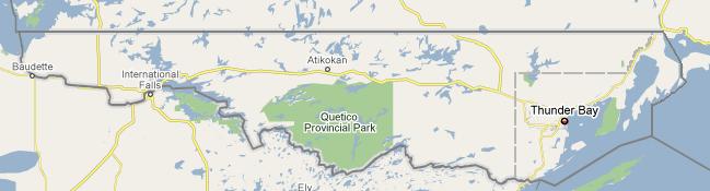
Geography
See maps.
Map of New Canada. Note that the dotted gray line is not the border between provinces, but the border between the "coast" and "inland" districts of Ontario Province. The province of Thunder Bay is just within the city limits.