SouthWriter (talk | contribs) (→Photo) |
(→Photo) |
||
| Line 118: | Line 118: | ||
Anyway, use it however you want, but contact me if you want to use it outside this website. --[[User:GOPZACK|Zack]] 21:31, March 12, 2012 (UTC) |
Anyway, use it however you want, but contact me if you want to use it outside this website. --[[User:GOPZACK|Zack]] 21:31, March 12, 2012 (UTC) |
||
| − | So that's in California, huh? |
+ | So that's in California, huh? Okay, it looks a little like it could be dropped in any forest, especially at lower resolution. I had to layer a forest atop a house (after snipping holes between the trees) to get the picture I have on Apaplachicola. Would transplanting this picture to replace my meager "photo-shop" attempt be okay? [[User:SouthWriter|SouthWriter]] 21:52, March 12, 2012 (UTC) |
| + | |||
| + | According to what's written on the back, it's where I said it was. But you're right. It could be used for any given forest. Use it anywhere on this website you'd like. --[[User:GOPZACK|Zack]] 23:32, March 14, 2012 (UTC) |
||
Revision as of 23:32, 14 March 2012
![7.1 New map of former USA and Canada: [[File:USACanada83.png]]](#New_map_of_former_USA_and_Canada:_[[File:USACanada83.png]])
Flag
Anyone got ideas for what the flag should be for the MSP? Mitro 21:35, 17 April 2009 (UTC)
This is probably not very original, but how about the US flag, only with a new number of stars representing each city state?--ShutUpNavi 03:59, 18 April 2009 (UTC)
Maybe, is there any other flag that may be notable for the region that can be used instead? Mitro 15:51, 18 April 2009 (UTC)
- There's the "Cascadia flag" with a Douglas fir, but that's almost become an Althistory cliche whenever there is an independent country in the Pacific Northwest. Benkarnell 18:42, 18 April 2009 (UTC)
- To true. Still maybe we could combine aspects of the Cascadia flag with the old US flag? Mitro 05:21, 19 April 2009 (UTC)
Here is an idea for the flag, I used parts of the US flag and another Cascadia flag I found. Mitro 20:06, 19 April 2009 (UTC)
Constitutional Convention?
I'm the one who made the recent changes regarding the constitutional convention. I'm just not sure that the current climate of the MSP would make this a reality. Except for Yreka, all the cities are pretty much ruled by barely civilized dictators, they would really need a reason to want to give up power like this. Maybe we could create a sort of civil war with a LoN negotiated peace which is followed by a convention as proposed? Mitro 15:56, 5 June 2009 (UTC)
Anythings fine by me, I was just trying to find an event that would make other nations see how corrupt the dictators and governors are I thought a war might be a bit far out for me to just make out of no where, but if you think it would work then lets go ahead but we ill need a gradual build up of events that would lead to civil war (city hordes LoN aid or a build up on the Jefferson nationalists issue).Trakov 23:52, 5 June 2009 (UTC)
- Well you have a democratic government in Yreka with a strong military. The MSP is receiving outside aide from the rest of the world. Meanwhile the Jefferson Nationalists (good idea there with creating that group, I really liked it) and CRUSA are campaigning or funding anyone who supports a strong central government. I think the climate is right for one city to do something stupid, like attacking agitators of democracy. Yreka intervene and the rest of the cities decide its finally time to end Yreka's threat to their power.
- Things don't go as well for the city-states. First the leader of Crescent City stages an attack on the CRUSA chapter house. Experienced with what happened in Hawaii, CRUSA agents successfully fend off the attack at first but are overwhelmed by larger numbers. The angry MSP men execute the remaining defenders, but its caught on tape by a foreigner who flees the country and spreads the information to the rest of the world. In an emergency meeting of the LoN the members agree that they need to intervene in the MSP conflict before things get further out of hand.
- Meanwhile Yreka goes on the offensive and attacks several other nearby cities, gaining new allies thanks to Jefferson Nationalists volunteers and a few nomads who sell their services (veterans of the fighting out west after all). Due to disputes over leadership and general disorganization, the city-states are late in getting their militaries together. Meanwhile the PSPU is split with some members going over to both sides.
- Eventually the MSP gets their shit together and begins to more effectively combat the Rebels. There are atrocities on both sides. Eventually though an international task force shows up and after capturing Crescent City and bombing several targets in the MSP, both sides agree to a cease fire and a new constitutional convention to work out the future of the MSP. Meanwhile more cities boil over as the oppressed classes turn on their leaders. Some flee, others are captured and tried. A few smart ones push through reforms and "abdicate" to stay in power. A few others try to use heavy handed tactics, but the LoN threatens to intervene if it continues.
- Thoughts? Mitro 02:42, 6 June 2009 (UTC)
Sounds Great!Trakov 02:49, 6 June 2009 (UTC)
- I'm starting to rethink my idea of a civil war. I wonder if the political climate currently would create a convention. O well I wrote something on the news board on the same page so we shall see what happens. Mitro 20:21, 7 June 2009 (UTC)
World Map
Does the MSP seem a little big on the main world map to anyone else either?Trakov 02:56, 6 June 2009 (UTC)
Republic of Victoria
So Victoria is sending an emissary to discuss a border for possible expansion in order to avoid stepping on toes. This wouldn't be an official border, just an agreement on a limit of expansion north for the MSP, and south for Victoria. I was thinking the Columbia River would be ideal.--Oerwinde 08:37, September 14, 2009 (UTC)
- Suddenly I had a vision of a bunch of MSP yahoos screaming "54'40 or fight"...Actually that wouldn't be far from the mark since CRUSA has generally been keeping to the policy that they will resist any attempt by other survivor states to encroach on former American territory. They might be able to stir up some resistance to this idea in the MSP. Mitro 14:48, September 14, 2009 (UTC)
- Well with the remoteness of the BC interior and much of the Washington infrastructure intact, southern expansion is easier than eastern expansion, and with the Washington Protectorate to vote on integration in November, its looking likely that much of Washington State will become part of Victoria anyway. I could definitely see CRUSA being a thorn in the side though.--Oerwinde 18:13, September 14, 2009 (UTC)
- Does the MSP even have any "territory" of its own? Its extent seems to be defined as "land that the individual cities have control of". Without MSP member cities, a land claim seems almost meaningless given the structure of the MSP. Benkarnell 02:58, October 16, 2009 (UTC)
- Its not so much as a land claim as a mutual agreement of expansion boundaries. Victoria would agree not to expand south of the Columbia river, the MSP north. Its mostly a courtesy so the MSP doesn't feel threatened by Victorian expansion.--Oerwinde 07:38, October 16, 2009 (UTC)
- Does the MSP even have any "territory" of its own? Its extent seems to be defined as "land that the individual cities have control of". Without MSP member cities, a land claim seems almost meaningless given the structure of the MSP. Benkarnell 02:58, October 16, 2009 (UTC)
- Well with the remoteness of the BC interior and much of the Washington infrastructure intact, southern expansion is easier than eastern expansion, and with the Washington Protectorate to vote on integration in November, its looking likely that much of Washington State will become part of Victoria anyway. I could definitely see CRUSA being a thorn in the side though.--Oerwinde 18:13, September 14, 2009 (UTC)
Off topic: another literature reference
I just finished reading, of all things, a nuclear post-apocalyptic children's novel, The People of Sparks, sequel to The City of Ember. It definitely renewed my enthusiasm for our own post-apoc. project. But what made me smile a little was that the main survivor community, Sparks, which all along you assume is just a symbolic-type name having to do with re-igniting the human race, turns out to be Sparks, Nevada. And a lot of the action takes place between Sparks and San Francisco. So why does so much nuclear holocaust fiction seem to focus on northern California ;)? Benkarnell 03:04, October 16, 2009 (UTC)
Sports
I'm chalking up the popularity of rugby union and soccer in the MSP to the direct influence of the Aussies and South Americans. The Aussies and South Americans also OK with baseball, figuring it to be the one American sport people would most remember; well, people also remember American football, but pads and helmets were (and still are) expensive to produce. It's cheaper just to bring over 100 or so rugby balls :) --BrianD 16:29, October 30, 2009 (UTC)
Population
Anyone know where the current population estimate originated? Seems a bit low, especially as I just finished looking at Victoria's population... I know the West Coast would get hit hard but I think there'd be at least a few more survivors. Anyone know the original reasoning here?--Loughery111 14:53, November 21, 2009 (UTC)
- The population is essentially half of todays population. I based this off the TL saying there was a large drop of population in the region. Arguably maybe half was too much, but I think the current set up of the MSP history wouldn't make it higher then today's standards. Mitro 15:20, November 21, 2009 (UTC)
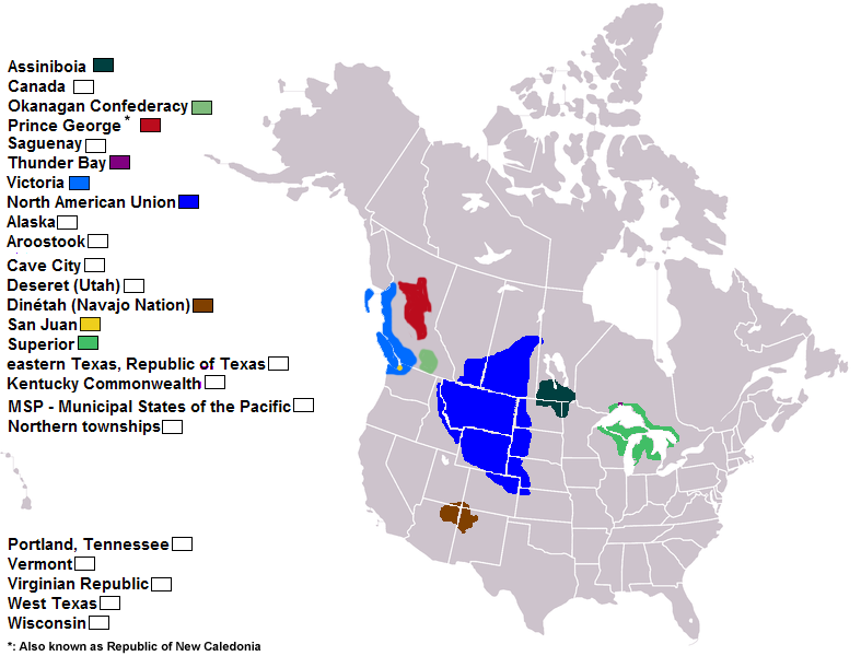
New map of former USA and Canada: [[File:USACanada83.png]]
paste a nation in the map and upload a new version of[[File:USACanada83.png]]
i created a new map to paste in there all new norther america nation, because we know limit inter brasil-venezuela, but what is the fontier canada-superior? where is easter texas? delmarva and virgina are in the same place? Dineta have sea cost? who of them have contact to great mexican republic? i paste North American Union in blue, around whyomyn, add your country and upload a new version of that file, i was count 23 entities in former USA and Canada, where?--Fero 01:22, November 23, 2009 (UTC)
Assiniboia has most of Manitoba, except for the Hudson Bay coast. Virginia has a good chunk of Southeast Ohio, most of Virginia, all of West Virginia and all of Maryland not under Delmarva control. And Lincoln has all of Nebraska not under NAU control.
--Yankovic270 01:32, November 23, 2009 (UTC)
- okey, you can paint the map to we all read that easyly and clearly--Fero 02:24, November 23, 2009 (UTC)
- look this, is relevant--Fero 02:53, November 24, 2009 (UTC)
Salem
I think Salem would have survived doomsday. It had negligible military presence, and being a state capital doesn't immediately warrant a nuke. In the 80s it only had a population of about 90 thousand, so it wasn't a major population center, and it two major employers were state government, and agriculture. I think its a candidate for inclusion in the MSP.--Oerwinde 11:32, January 10, 2010 (UTC)
- When I wrote the article for the MSP, I did not add Salem because it was too far north from where the TL and other articles suggested the founding city-states were located. Also Salem is pretty close to Portland, isn't it possible that the destruction of the city and the refugee problem could lead to Salem being made uninhabitable? Mitro 00:52, January 11, 2010 (UTC)
- As Salem is 46 miles south of Portland, it's possible that the hits might affect the city, but it would depend on what kind of nukes the Russians sent to destroy Portland. It's very possible that Salem was one of the state capitals that fell apart in violence after DD.--BrianD 02:13, January 11, 2010 (UTC)
- Well, Portland would be mostly an industrial/economic target, so a lower yield nuke would likely get the job done. Perhaps it originally fell apart and only recently stabilized. It could be something that happens in the future. Just throwing it out there.--Oerwinde 05:26, January 11, 2010 (UTC)
Living standards/rights/such and such
what are the current living conditions and rights of citizens of the MSP?--HAD 11:09, March 24, 2010 (UTC)
- Apparently greatly improved, thus the present reconsideration of the population. I am presenting below my preliminary considerations on the matter [the 'Population Nazi'] SouthWriter 19:17, March 30, 2010 (UTC)
reconsidering population, comments welcome
Having added the 2000 census figures of the most likely counties and cities, I reached a figure of 914,068. Reducing that by 17% you get 758,676 for the area in 1983. Half that is 379,338. If we then assume that this population has 20 years (1990 to 2010) to grow at 1%, we come to 455,206. If the harsh conditions in the earlier years are not as bad, and there is migration into the area once the warlords are overthrown, then the population can be seen to be considerably better, even surpassing OTL. I think that the present estimate in the article is about right, though a little low. A figure in the range of about a half million would probably be better. --SouthWriter (aka Population Nazi) 19:17, March 30, 2010 (UTC)
- 1980 was a census year, why not just use that figure? Mitro 20:31, March 30, 2010 (UTC)
- The figures I used were all from Wikipedia articles of counties and cities. The only figures readily available were either for 2007 or 2000.(sometimes both). I could have gone to the states (where all the census years are included) and estrapolated using the increase between 1980 and 1990, but the increase in the rural areas would not have been the same as in urban areas. Instead, I chose to go backwards assuming a modest increase of 1% per year. SouthWriter 22:38, March 30, 2010 (UTC)
UPDATE I went back and used only the most likely counties around the cities mentioned on the state line. I have not included Bay City, OR (too far north and too close to Portland) nor Placerville (too far south and "in" Sierra Nevada Union). 2009 estimates OTL add up to 377,610. And that includes very mountainous and rural Trinity county with its two towns near Redding. Without that county (not mentioned in the article) the population OTL is around 364,600. Either way, the present population in TTL is about right without drastic cuts. If we assumed a lot of death due to harsh conditions (though no nukes), then maybe 200,000 or so would be about right. Population Nazi 7:12, May 12, 2010 (UTC)
Which towns?
I did some checking. Based on the article, and disregarding the infobox (though the map is actually pretty close) we are looking


at six or seven counties. The population OTL is a little over 350,000 for those counties. However, there are two cties that probably should not be included -- Bay City, OR, and Placerville, CA. They are too far north and south, respectively.
Also, Bay City is too close to Portland, OR, a probable target. Placerville is probably part of the Siera Nevada Union. If we take these cities out of the picture, SNU can develop with few problems, and we can squeeze the proposed Commonwealth of California in between the two (even giving in a coast!). SouthWriter 05:23, May 12, 2010 (UTC)
I was reading your discussion and wanted to let you know I had not really given any thought to anything west of the Sierra Nevada Mountain range as being part of the SNU. The mountains are very rugged and act as a fairly decent natural barrier/border between the SNU and the northern and central areas of California. I included only those parts of El Dorado, Placer, Alpine, and Mono Counties east of the mountains as logically wanting to join the SNU. I would imagine, the SNU patrols the mountains up to a certain point and his several forts for security, but that would be it. If you think at some point I should include Placerville, let me know. I hope this helps with your mapping process.--Fxgentleman 12:15, May 12, 2010 (UTC)
- True enough, the mountains do form a fomidable boundary. My point, though, was that Placerville is so far removed from the bulk of the MSP that I can imagine it was probably thrown in, like Bay City, as a small town in the area that needed to find allies. Neither is not included in the body of the article, only being included among the "other cities" in the infobox. The rough map provided from the beginning coresponds with the clump of counties on the CA/OR border only. My map, by the way, is mostly just a personal project. No one seems to use it but me. I like to get an idea what's going on. SouthWriter 14:10, May 12, 2010 (UTC)
No problem. In regards to Placerville, I have had serious doubts about its survivability anyway given its proximity to Sacramento and exposure to fallout. Of course, there has never been any discussion about how large the Sacramento attack would been. I have to confess being a bit unsure myself on the MSP's boundaries to some extent when I was creating my own article. Looking at your map, it seems to paint what I would think is a more realistic picture than the larger map does in regards to the MSP.--Fxgentleman 14:22, May 12, 2010 (UTC)
Democratic vote, don't forget!
Just a reminder it is stated in the info on this page that the nation is to have a democratic government in power by september, and well its september 29, so Im jsut making sure the author rembers what he put. Riley.Konner 09:28 September 29 2010 (UTC)
If international observers, well, observe correctly, the vote shall go forward.HAD 16:33, September 29, 2010 (UTC)
- Damn your right. I guess I am going to have to retcon the event. Mitro 16:51, September 29, 2010 (UTC)
Photo
I was going through some old family photos and thought you guys may appreciate this.


It's a photo of the Darlingonia Cottages located just 20 miles from Crescent City. The photo is from 1965 and I reckon you guys may want to use it as photo of what living conditions were like in some areas.
Anyway, use it however you want, but contact me if you want to use it outside this website. --Zack 21:31, March 12, 2012 (UTC)
So that's in California, huh? Okay, it looks a little like it could be dropped in any forest, especially at lower resolution. I had to layer a forest atop a house (after snipping holes between the trees) to get the picture I have on Apaplachicola. Would transplanting this picture to replace my meager "photo-shop" attempt be okay? SouthWriter 21:52, March 12, 2012 (UTC)
According to what's written on the back, it's where I said it was. But you're right. It could be used for any given forest. Use it anywhere on this website you'd like. --Zack 23:32, March 14, 2012 (UTC)