(Created page with "'''Vinlandia '''is the northern continent of the western hemisphere. Norwegian settlers when they first arrived on the continent named it Vinland, after the fabled lands discover…") |
mNo edit summary |
||
| (17 intermediate revisions by 4 users not shown) | |||
| Line 1: | Line 1: | ||
'''Vinlandia '''is the northern continent of the western hemisphere. Norwegian settlers when they first arrived on the continent named it Vinland, after the fabled lands discovered by Erik the Red. When word was received by other nations they began calling it Vinlandia, to differentiate it from the Norwegian colonies. |
'''Vinlandia '''is the northern continent of the western hemisphere. Norwegian settlers when they first arrived on the continent named it Vinland, after the fabled lands discovered by Erik the Red. When word was received by other nations they began calling it Vinlandia, to differentiate it from the Norwegian colonies. |
||
| + | ==Etymology== |
||
| + | Vinlandia takes its name from a land once discovered by Norsemen around 1000 CE. Norse explorers at the time discovered a land they called Vinland, old norse for Wine-land. When Norwegian explorers and refugees landed on the coast of what is now referred to as Markland, they began attributing the names Leif Eriksson gave for lands he discovered. When more Norwegian settlers began arriving they mostly settled in the lands south of where they first made landfall, calling the land Vinland. Over time as the Vinland colony became more important economically, and other European nations began exploring the new land, people began referring to the land as a whole as Vinlandia, to differentiate it from the Vinland colony itself. |
||
| + | |||
| + | ==Geography and Extent== |
||
| + | Vinlandia occupies the northern portion of the region known as the Western Hemisphere. The continent is [[File:SV_-_NorthAmericaSatellite.png|thumb|Satellite Image of Vinlandia]]generally delimited on the southeast by the Strait of Columbus. The islands of the West Indies delineate a submerged former land bridge, which had connected Vinlandia and [[Cortez (Sundered Veil)|Cortez ]] via what are now Florida and Venezuela. Much of Vinlandia is on the Vinlandic Plate. |
||
| + | |||
| + | The continental coastline is long and irregular. The Gulf of Mexico is the largest body of water indenting the continent, followed by Hudson Bay. Others include the Gulf of Eriksson and the Gulf of California. |
||
| + | |||
| + | There are numerous islands off the continent’s coasts: principally, the Arctic Archipelago, the Bahamas, Turks & Caicos, the Greater and Lesser Antilles, the Aleutian Islands (some of which are in the eastern hemisphere proper), the Alexander Archipelago, the many thousand islands of the British Columbia Coast, the many islands of the Westhansa Sea, and [[Vinland (Sundered Veil)|Vinland]]. Greenland, a self-governing [[Denmark (Sundered Veil)|Danish]] island, and the world's largest, is on the same tectonic plate (the Vinlandic Plate) and is part of Vinlandia geographically. In a geologic sense, Bermuda is not part of Vinlandia, but an oceanic island which was formed on the fissure of the Mid-Atlantic Ridge over 100 million years ago. The nearest landmass to it is Cape Hatteras, Roanoke. However, Bermuda is often thought of as part of Vinlandia, especially given its historical, political and cultural ties to New Coventry and other parts of the continent. |
||
| + | |||
| + | ==Countries and Territories== |
||
| + | {| border="1" cellpadding="0" cellspacing="0" style="width: 500px;" |
||
| + | | style="text-align: center; background-color: rgb(204, 204, 204); border-color: rgb(170, 170, 170);"|'''Country or Territory''' |
||
| + | | style="text-align: center; background-color: rgb(204, 204, 204); border-color: rgb(170, 170, 170);"|'''Area''' |
||
| + | | style="text-align: center; background-color: rgb(204, 204, 204); border-color: rgb(170, 170, 170);"|'''Population''' |
||
| + | | style="text-align: center; background-color: rgb(204, 204, 204); border-color: rgb(170, 170, 170);"|'''Capital''' |
||
| + | |- |
||
| + | | colspan="4" style="text-align: center; background-color: rgb(236, 236, 236); border-color: rgb(170, 170, 170);"|'''Vinlandia''' |
||
| + | |- |
||
| + | | style="background-color: rgb(236, 236, 236); border-color: rgb(170, 170, 170);"|[[File:SV-AlaskaFlag.png|22px]] [[Alaska (Sundered Veil)|Alaska ]] |
||
| + | | style="background-color: rgb(236, 236, 236); border-color: rgb(170, 170, 170); text-align: right;"| |
||
| + | | style="background-color: rgb(236, 236, 236); border-color: rgb(170, 170, 170); text-align: right;"| |
||
| + | | style="background-color: rgb(236, 236, 236); border-color: rgb(170, 170, 170);"|New Archangel |
||
| + | |- |
||
| + | | style="background-color: rgb(236, 236, 236); border-color: rgb(170, 170, 170);"|[[File:SV-KaliforniaFlag.png|22px]][[Kalifornia (Sundered Veil)|Kalifornia]] |
||
| + | | style="background-color: rgb(236, 236, 236); border-color: rgb(170, 170, 170); text-align: right;"| |
||
| + | | style="background-color: rgb(236, 236, 236); border-color: rgb(170, 170, 170); text-align: right;"| |
||
| + | | style="background-color: rgb(236, 236, 236); border-color: rgb(170, 170, 170);"|Westhansa |
||
| + | |- |
||
| + | | style="background-color: rgb(236, 236, 236); border-color: rgb(170, 170, 170);"|[[File:SV-CharlesianeFlag.png|22px]][[Charlesiane (Sundered Veil)|Charlesiane]] |
||
| + | | style="background-color: rgb(236, 236, 236); border-color: rgb(170, 170, 170); text-align: right;"| |
||
| + | | style="background-color: rgb(236, 236, 236); border-color: rgb(170, 170, 170); text-align: right;"| |
||
| + | | style="background-color: rgb(236, 236, 236); border-color: rgb(170, 170, 170);"|New Orleans |
||
| + | |- |
||
| + | | style="background-color: rgb(236, 236, 236); border-color: rgb(170, 170, 170);"|[[Commanche Confederacy (Sundered Veil)|Commanche Confederacy]] |
||
| + | | style="background-color: rgb(236, 236, 236); border-color: rgb(170, 170, 170); text-align: right;"| |
||
| + | | style="background-color: rgb(236, 236, 236); border-color: rgb(170, 170, 170); text-align: right;"| |
||
| + | | style="background-color: rgb(236, 236, 236); border-color: rgb(170, 170, 170);"| |
||
| + | |- |
||
| + | | style="background-color: rgb(236, 236, 236); border-color: rgb(170, 170, 170);"|[[File:SV-CVSFlag.png|22px]][[Commonwealth of Vinlandian States (Sundered Veil)| Commonwealth of Vinlandian States]] |
||
| + | | style="background-color: rgb(236, 236, 236); border-color: rgb(170, 170, 170); text-align: right;"| |
||
| + | | style="background-color: rgb(236, 236, 236); border-color: rgb(170, 170, 170); text-align: right;"| |
||
| + | | style="background-color: rgb(236, 236, 236); border-color: rgb(170, 170, 170);"|Adams, DC |
||
| + | |- |
||
| + | | style="background-color: rgb(236, 236, 236); border-color: rgb(170, 170, 170);"|Greenland ([[Denmark (Sundered Veil)|Den.]]) |
||
| + | | style="background-color: rgb(236, 236, 236); border-color: rgb(170, 170, 170); text-align: right;"| |
||
| + | | style="background-color: rgb(236, 236, 236); border-color: rgb(170, 170, 170); text-align: right;"| |
||
| + | | style="background-color: rgb(236, 236, 236); border-color: rgb(170, 170, 170);"|Nuuk |
||
| + | |- |
||
| + | | style="background-color: rgb(236, 236, 236); border-color: rgb(170, 170, 170);"|[[File:SV-HaidaFlag.png|22px]][[Haida Confederacy (Sundered Veil)|Haida ]] |
||
| + | | style="background-color: rgb(236, 236, 236); border-color: rgb(170, 170, 170); text-align: right;"| |
||
| + | | style="background-color: rgb(236, 236, 236); border-color: rgb(170, 170, 170); text-align: right;"| |
||
| + | | style="background-color: rgb(236, 236, 236); border-color: rgb(170, 170, 170);"|Skidegate |
||
| + | |- |
||
| + | | style="background-color: rgb(236, 236, 236); border-color: rgb(170, 170, 170);"| [[File:SV-MexicoFlag.png|22px]] [[Mexico (Sundered Veil)|Mexico ]] |
||
| + | | style="background-color: rgb(236, 236, 236); border-color: rgb(170, 170, 170); text-align: right;"| |
||
| + | | style="background-color: rgb(236, 236, 236); border-color: rgb(170, 170, 170); text-align: right;"| |
||
| + | | style="background-color: rgb(236, 236, 236); border-color: rgb(170, 170, 170);"|Mexico City |
||
| + | |- |
||
| + | | style="background-color: rgb(236, 236, 236); border-color: rgb(170, 170, 170);"|[[File:SV-NewAlbionFlag.png|22px]][[New Albion (Sundered Veil)|New Albion ]] |
||
| + | | style="background-color: rgb(236, 236, 236); border-color: rgb(170, 170, 170); text-align: right;"| |
||
| + | | style="background-color: rgb(236, 236, 236); border-color: rgb(170, 170, 170); text-align: right;"| |
||
| + | | style="background-color: rgb(236, 236, 236); border-color: rgb(170, 170, 170);"|Guinevere |
||
| + | |- |
||
| + | | style="background-color: rgb(236, 236, 236); border-color: rgb(170, 170, 170);"|[[File:SV-Vanaheim.png|22px]][[Asatheim (Sundered Veil)|Asatheim]] |
||
| + | | style="background-color: rgb(236, 236, 236); border-color: rgb(170, 170, 170); text-align: right;"| |
||
| + | | style="background-color: rgb(236, 236, 236); border-color: rgb(170, 170, 170); text-align: right;"| |
||
| + | | style="background-color: rgb(236, 236, 236); border-color: rgb(170, 170, 170);"|Njordland |
||
| + | |- |
||
| + | | style="background-color: rgb(236, 236, 236); border-color: rgb(170, 170, 170);"|[[File:SV-VinlandFlag.png|22px]][[Vinland (Sundered Veil)| Vinland ]] |
||
| + | | style="background-color: rgb(236, 236, 236); border-color: rgb(170, 170, 170); text-align: right;"| |
||
| + | | style="background-color: rgb(236, 236, 236); border-color: rgb(170, 170, 170); text-align: right;"| |
||
| + | | style="background-color: rgb(236, 236, 236); border-color: rgb(170, 170, 170);"|Liefheim |
||
| + | |- |
||
| + | | colspan="4" style="text-align: center; background-color: rgb(236, 236, 236); border-color: rgb(170, 170, 170);"|'''Caribbean''' |
||
| + | |- |
||
| + | | style="background-color: rgb(236, 236, 236); border-color: rgb(170, 170, 170);"|[[File:Flag of Barbados.svg|22px]][[Barbados (Sundered Veil)| Barbados]] |
||
| + | | style="background-color: rgb(236, 236, 236); border-color: rgb(170, 170, 170); text-align: right;"| |
||
| + | | style="background-color: rgb(236, 236, 236); border-color: rgb(170, 170, 170); text-align: right;"| |
||
| + | | style="background-color: rgb(236, 236, 236); border-color: rgb(170, 170, 170);"|Bridgetown |
||
| + | |- |
||
| + | | style="background-color: rgb(236, 236, 236); border-color: rgb(170, 170, 170);"|[[Cuba (Sundered Veil)|Cuba]] |
||
| + | | style="background-color: rgb(236, 236, 236); border-color: rgb(170, 170, 170); text-align: right;"| |
||
| + | | style="background-color: rgb(236, 236, 236); border-color: rgb(170, 170, 170); text-align: right;"| |
||
| + | | style="background-color: rgb(236, 236, 236); border-color: rgb(170, 170, 170);"|Havana |
||
| + | |- |
||
| + | | style="background-color: rgb(236, 236, 236); border-color: rgb(170, 170, 170);"|[[File:Flag_of_the_Dominican_Republic.png|22px]][[Dominican Republic (Sundered Veil)| Dominican Republic]] |
||
| + | | style="background-color: rgb(236, 236, 236); border-color: rgb(170, 170, 170); text-align: right;"| |
||
| + | | style="background-color: rgb(236, 236, 236); border-color: rgb(170, 170, 170); text-align: right;"| |
||
| + | | style="background-color: rgb(236, 236, 236); border-color: rgb(170, 170, 170);"|Santo Domingo |
||
| + | |- |
||
| + | | style="background-color: rgb(236, 236, 236); border-color: rgb(170, 170, 170);"|[[East Caribbean Federation (Sundered Veil)|East Caribbean Federation]] ([[United Kingdom (Sundered Veil)|UK]]) |
||
| + | | style="background-color: rgb(236, 236, 236); border-color: rgb(170, 170, 170); text-align: right;"| |
||
| + | | style="background-color: rgb(236, 236, 236); border-color: rgb(170, 170, 170); text-align: right;"| |
||
| + | | style="background-color: rgb(236, 236, 236); border-color: rgb(170, 170, 170);"|St Johns |
||
| + | |- |
||
| + | | style="background-color: rgb(236, 236, 236); border-color: rgb(170, 170, 170);"|[[French Caribbean (Sundered Veil)|French Caribbean]] |
||
| + | | style="background-color: rgb(236, 236, 236); border-color: rgb(170, 170, 170); text-align: right;"| |
||
| + | | style="background-color: rgb(236, 236, 236); border-color: rgb(170, 170, 170); text-align: right;"| |
||
| + | | style="background-color: rgb(236, 236, 236); border-color: rgb(170, 170, 170);"|Fort-de-France |
||
| + | |- |
||
| + | | style="background-color: rgb(236, 236, 236); border-color: rgb(170, 170, 170);"|[[File:Flag_of_Haiti.svg|22px]][[Haiti (Sundered Veil)| Haiti]] |
||
| + | | style="background-color: rgb(236, 236, 236); border-color: rgb(170, 170, 170); text-align: right;"| |
||
| + | | style="background-color: rgb(236, 236, 236); border-color: rgb(170, 170, 170); text-align: right;"| |
||
| + | | style="background-color: rgb(236, 236, 236); border-color: rgb(170, 170, 170);"|Port-au-Prince |
||
| + | |- |
||
| + | | style="background-color: rgb(236, 236, 236); border-color: rgb(170, 170, 170);"|[[Jamaika (Sundered Veil)|Jamaika]] |
||
| + | | style="background-color: rgb(236, 236, 236); border-color: rgb(170, 170, 170); text-align: right;"| |
||
| + | | style="background-color: rgb(236, 236, 236); border-color: rgb(170, 170, 170); text-align: right;"| |
||
| + | | style="background-color: rgb(236, 236, 236); border-color: rgb(170, 170, 170);"|Neuer Kiel |
||
| + | |- |
||
| + | | style="background-color: rgb(236, 236, 236); border-color: rgb(170, 170, 170);"|[[North Caribbean Federation (Sundered Veil)|North Caribbean Federation]] ([[United Kingdom (Sundered Veil)|UK ]]) |
||
| + | | style="background-color: rgb(236, 236, 236); border-color: rgb(170, 170, 170); text-align: right;"| |
||
| + | | style="background-color: rgb(236, 236, 236); border-color: rgb(170, 170, 170); text-align: right;"| |
||
| + | | style="background-color: rgb(236, 236, 236); border-color: rgb(170, 170, 170);"|Nassau |
||
| + | |- |
||
| + | | style="background-color: rgb(236, 236, 236); border-color: rgb(170, 170, 170);"|[[Puerto Rico (Sundered Veil)|Puerto Rico]] ([[Spain (Sundered Veil)|Spa.]]) |
||
| + | | style="background-color: rgb(236, 236, 236); border-color: rgb(170, 170, 170); text-align: right;"| |
||
| + | | style="background-color: rgb(236, 236, 236); border-color: rgb(170, 170, 170); text-align: right;"| |
||
| + | | style="background-color: rgb(236, 236, 236); border-color: rgb(170, 170, 170);"|San Juan |
||
| + | |} |
||
[[File:SV_-_NorthAmericaPolitical.png|thumb|Political boundaries of modern Vinlandia]] |
[[File:SV_-_NorthAmericaPolitical.png|thumb|Political boundaries of modern Vinlandia]] |
||
[[Category:Sundered Veil]] |
[[Category:Sundered Veil]] |
||
| + | [[Category:North America]] |
||
Latest revision as of 00:18, 26 April 2013
Vinlandia is the northern continent of the western hemisphere. Norwegian settlers when they first arrived on the continent named it Vinland, after the fabled lands discovered by Erik the Red. When word was received by other nations they began calling it Vinlandia, to differentiate it from the Norwegian colonies.
Etymology
Vinlandia takes its name from a land once discovered by Norsemen around 1000 CE. Norse explorers at the time discovered a land they called Vinland, old norse for Wine-land. When Norwegian explorers and refugees landed on the coast of what is now referred to as Markland, they began attributing the names Leif Eriksson gave for lands he discovered. When more Norwegian settlers began arriving they mostly settled in the lands south of where they first made landfall, calling the land Vinland. Over time as the Vinland colony became more important economically, and other European nations began exploring the new land, people began referring to the land as a whole as Vinlandia, to differentiate it from the Vinland colony itself.
Geography and Extent
Vinlandia occupies the northern portion of the region known as the Western Hemisphere. The continent is
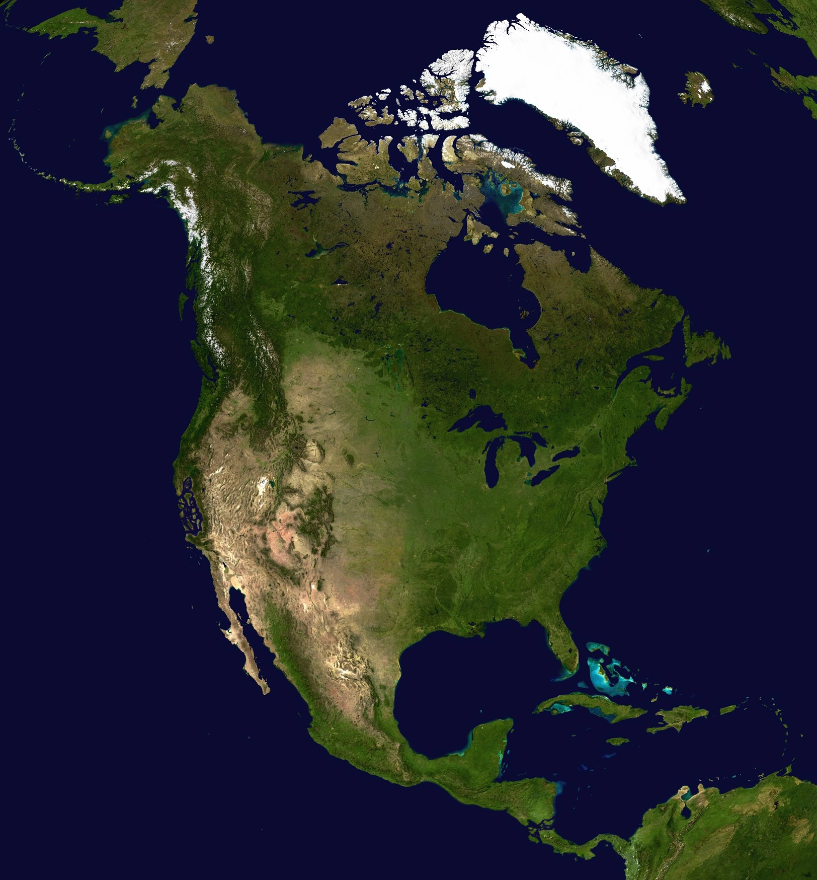
Satellite Image of Vinlandia
generally delimited on the southeast by the Strait of Columbus. The islands of the West Indies delineate a submerged former land bridge, which had connected Vinlandia and Cortez via what are now Florida and Venezuela. Much of Vinlandia is on the Vinlandic Plate.
The continental coastline is long and irregular. The Gulf of Mexico is the largest body of water indenting the continent, followed by Hudson Bay. Others include the Gulf of Eriksson and the Gulf of California.
There are numerous islands off the continent’s coasts: principally, the Arctic Archipelago, the Bahamas, Turks & Caicos, the Greater and Lesser Antilles, the Aleutian Islands (some of which are in the eastern hemisphere proper), the Alexander Archipelago, the many thousand islands of the British Columbia Coast, the many islands of the Westhansa Sea, and Vinland. Greenland, a self-governing Danish island, and the world's largest, is on the same tectonic plate (the Vinlandic Plate) and is part of Vinlandia geographically. In a geologic sense, Bermuda is not part of Vinlandia, but an oceanic island which was formed on the fissure of the Mid-Atlantic Ridge over 100 million years ago. The nearest landmass to it is Cape Hatteras, Roanoke. However, Bermuda is often thought of as part of Vinlandia, especially given its historical, political and cultural ties to New Coventry and other parts of the continent.
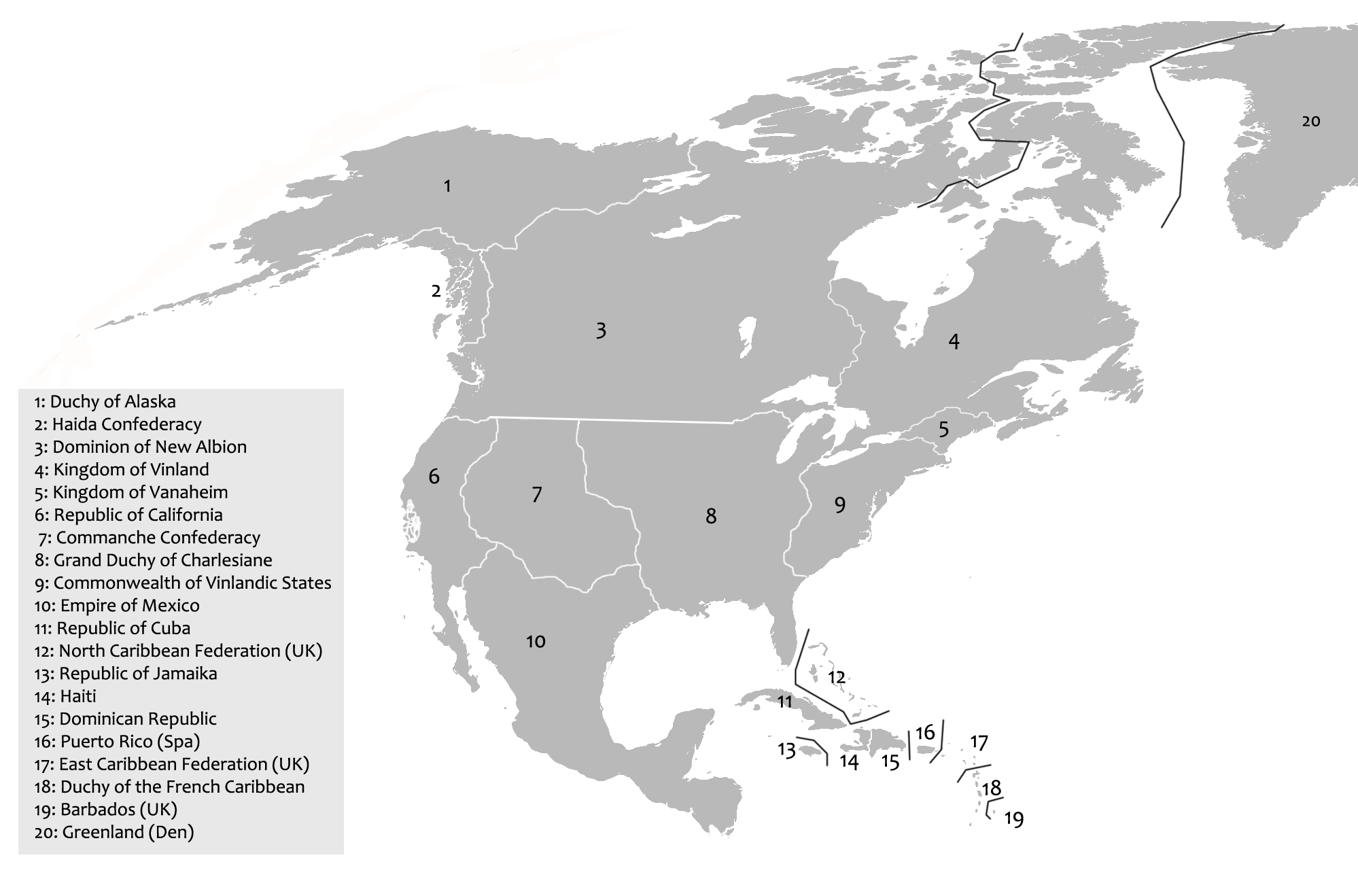
Countries and Territories
| Country or Territory | Area | Population | Capital |
| Vinlandia | |||
| New Archangel | |||
| Westhansa | |||
| New Orleans | |||
| Commanche Confederacy | |||
| Adams, DC | |||
| Greenland (Den.) | Nuuk | ||
| Skidegate | |||
| Mexico City | |||
| Guinevere | |||
| Njordland | |||
| Liefheim | |||
| Caribbean | |||
| Bridgetown | |||
| Cuba | Havana | ||
| File:Flag of the Dominican Republic.png Dominican Republic | Santo Domingo | ||
| East Caribbean Federation (UK) | St Johns | ||
| French Caribbean | Fort-de-France | ||
| Port-au-Prince | |||
| Jamaika | Neuer Kiel | ||
| North Caribbean Federation (UK ) | Nassau | ||
| Puerto Rico (Spa.) | San Juan | ||
Political boundaries of modern Vinlandia